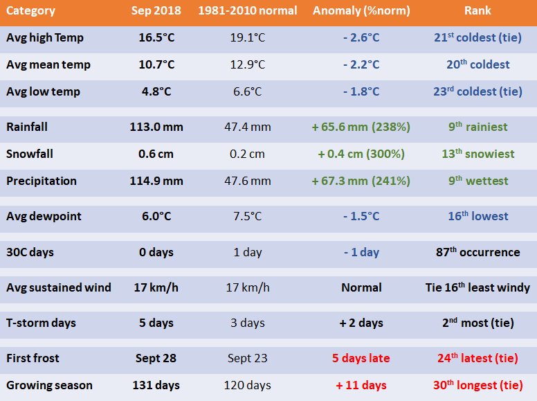
1 - Stats and Rankings
2 - Daily Records
- Sep 16 - High dewpoint 19.6C. Old record 18.6C in 2006.
- Sep 16 - High humidex 33.9. Old record 33.7 in 1979.
- Sep 22 - High snowfall 0.4 cm. Never snowed previously on this date since 1872. Also 3rd earliest measurable snowfall.
- Sep 23 - Low maximum temperature 6.0C. Old record 6.7C in 1946.
- Sep 28 - High snow depth of trace. Never had snow on ground at 12 UTC observation on this date since 1955. Also only 2nd time there was snow on ground at 12 UTC observation in September since 1955.
- Sep 29 - Low wind chill -8.4. Old record -8.1 in 1964.
- Sep 30 - Low dewpoint -11.1C. Old record -8.3C in 1960. Also all-time lowest in September since 1955.
3 - Other
- 34% of yearly precipitation up to September fell in September. Normally, only 11% of precipitation from January to September would fall in September.
- First occurrence of snow in September since 2003 and first measurable snowfall in September since 1984.
- Wettest and rainiest September since 1977.
- 5th wettest first half of September since 1872.
- Incredible temperature gradient across southern Manitoba on Sep 16.
- September broke an 11-consecutive month streak of drier than normal months (October 2017 to August 2018), the longest on record when comparing with a previous 30-year average.
- 46.6 mm of rain on September 12 at the Airport was the 6th rainiest September day on record in the city since 1872. 62.9 mm fell during the night of September 12-13, 133% of the monthly normal. The storms also brought up to nickel sized hail in the city. Up to 60 mm of rain fell in 1 hour in some parts of the city.
- High of 3.7C on Sept 28 was the coldest in September since Sept 28, 1981 (2.9C).
- 7 days with a high in the single digits, tied 2nd most in September since 1872. Most was 8 days in 1873.
- Brandon's snowfall on September 22 was the first in September since 1999.
- 4 days with snow reported at the Airport, and 2 days with measurable snowfall in Winnipeg. The snow on September 22 caused treacherous highways and power outages across southern Manitoba. 5 to 10 cm fell south, west and east of Winnipeg.
 RSS Feed
