FEBRUARY Daily Precipitation Records - WINNIPEG (since 1873)
|
Day |
High rainfall |
High
snowfall |
High Precip |
Day |
|||
|
1 |
T |
7
years |
10.9 |
1953 |
10.9 |
1953 |
1 |
|
2 |
T |
1940**** |
12.7 |
1914* |
12.7 |
1914* |
2 |
|
3 |
0.5 |
1975 |
10.0 |
2019 |
6.4 |
1915 |
3 |
|
4 |
2.0 |
2011 |
25.1 |
1881 |
25.1 |
1881 |
4 |
|
5 |
2.5 |
1963 |
19.3 |
1908 |
19.3 |
1908 |
5 |
|
6 |
5.1 |
1878 |
14.2 |
1881 |
14.2 |
1881 |
6 |
|
7 |
1.2 |
2024 |
17.3 |
1881 |
17.3 |
1881 |
7 |
|
8 |
1.5 |
1999 |
7.9 |
1881 |
7.9 |
1881 |
8 |
|
9 |
13.2 |
2009 E |
11.4 |
1894 |
13.2 |
2009 E |
9 |
|
10 |
0.3 |
2009 E |
8.2 |
2022 |
7.9 |
1922 |
10 |
|
11 |
2.0 |
1934 |
9.1 |
1895 |
9.1 |
1895 |
11 |
|
12 |
0.5 |
1973 |
16.0 |
1938 O |
16.0 |
1938 O |
12 |
|
13 |
0.3 |
1962 |
15.2 |
1938 |
15.2 |
1938 |
13 |
|
14 |
0.3 |
1947* |
15.2 |
1915 |
15.2 |
1915 |
14 |
|
15 |
4.0 |
1984 |
18.0 |
1962 |
13.5 |
1962 |
15 |
|
16 |
1.0 |
1998 |
25.4 |
1921 |
25.4 |
1921 |
16 |
|
17 |
0.6 |
1992 |
15.2 |
1873 |
15.2 |
1873 |
17 |
|
18 |
0.5 |
1983 |
15.2 |
1884 |
15.2 |
1884 |
18 |
|
19 |
0.7 |
1983 |
12.0 |
2022 |
7.1 |
2022 U |
19 |
|
20 |
1.1 |
2017 |
23.6 |
1955 |
23.6 |
1955 |
20 |
|
21 |
5.8 |
1877 |
6.4 |
1980 |
6.4 |
1980 |
21 |
|
22 |
5.6 |
1996 |
11.7 |
1930 |
14.2 |
1930 |
22 |
|
23 |
7.6 |
1958 |
14.5 |
1948 |
14.5 |
1948 |
23 |
|
24 |
2.5 |
1951 |
11.5 |
1977 |
11.5 |
1977 |
24 |
|
25 |
20.0 |
2000 |
15.7 |
1910 |
20.5 |
1998 |
25 |
|
26 |
10.5 |
1998 |
15.2 |
1873 |
15.2 |
1873 |
26 |
|
27 |
1.9 |
1983 |
6.4 |
1873* |
9.0 |
1998 |
27 |
|
28 |
1.5 |
1895 |
10.4 |
1987 |
9.6 |
1987 |
28 |
|
29 |
0.0 |
4.1 |
2004 |
3.0 |
1884 |
29 |
|
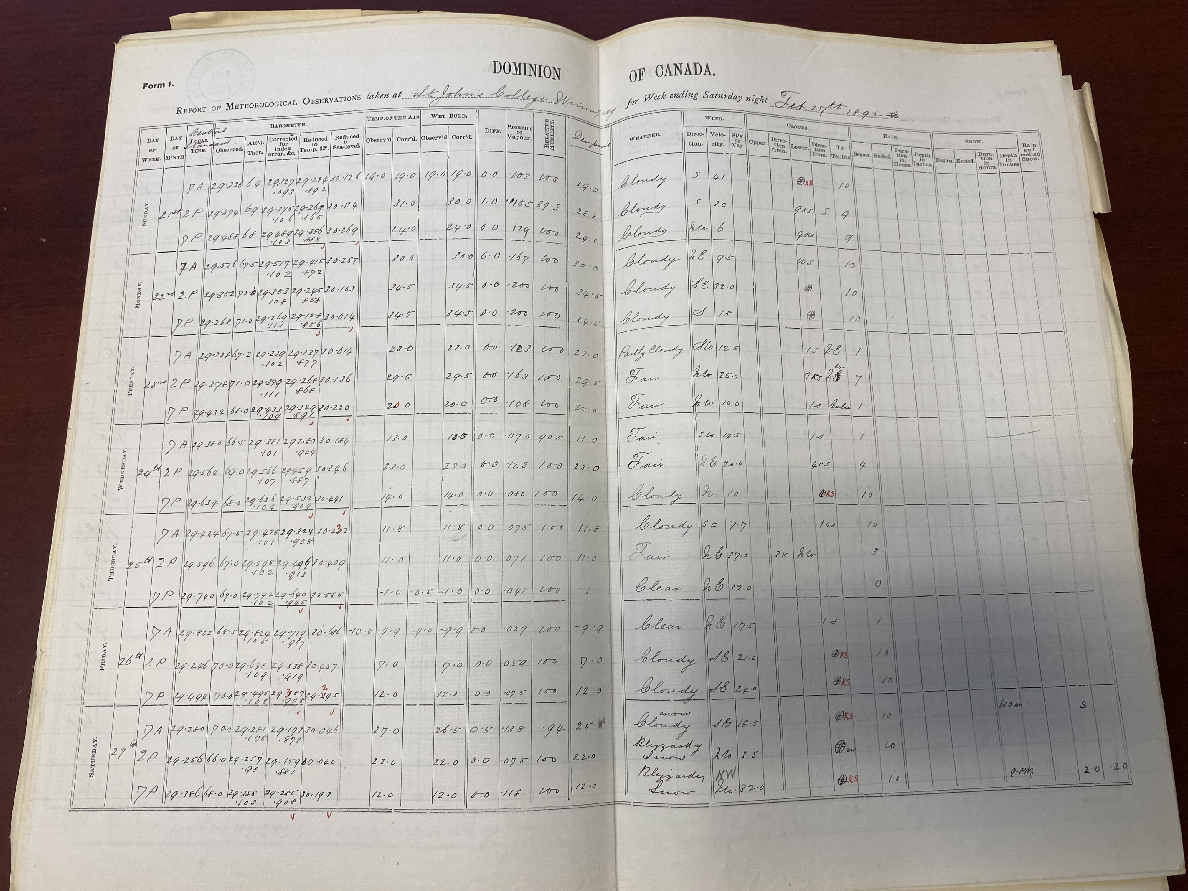
Feb 29, 1892 - All indications show the 5.1 cm snowfall occurring on the 27th instead of the 29th. St John's College observer notes show the snow on the 27th. All other stations in southern Manitoba also show the snowstorm occurring on the 27th. I have moved the event to the 27th as a result, eliminating the 29th snow/precip records.
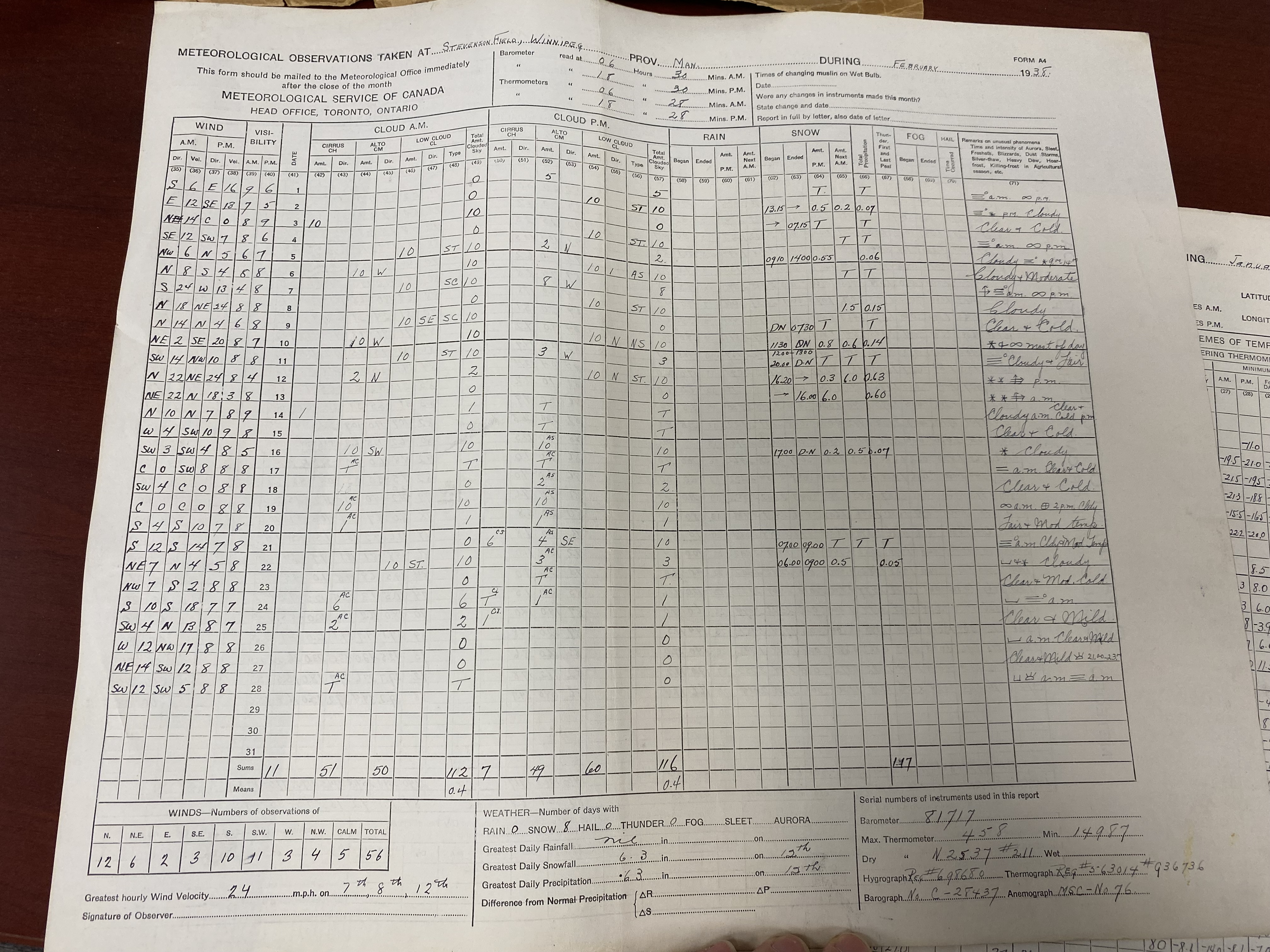
Feb 12, 1938 - Missing snowfall amount at the Airport was found at the Library Archives of Canada in Winnipeg.
Feb 19-20, 1997 - 1.0 mm of rain on the 19th is not in the table above, because it actually fell on the 20th. I moved the 1.0 mm to the 20th as a result.
Feb 9 and 10, 2009 - Rain/precip amounts from CXWG (Airport auto station) are used due to YWG nipher shield issues causing unrealistically high rainfall amounts.
Feb 19, 2022 - Significant wind/blowing snow likely caused undercatch at the Airport. The Forks precip used instead, since it was more sheltered/representative.
Graph form:

