Historical Snowfall and Blizzard Events
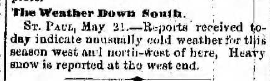
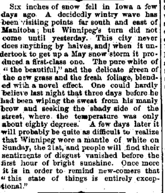
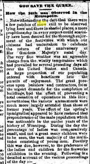
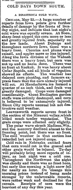
Winnipeg residents awoke to ''a mantle of white'' the morning of May 21st, 1882, as a result of an unusually late snowstorm which struck during the night. There is not much information available about the storm, but it appears it was quite extensive, suggesting a Colorado Low. Winnipeg received 15 cm, while the Manitoba Free Press mentioned 30 cm (a foot) in the Carberry area. St Paul, Minnesota, mentioned heavy snow west of there, suggesting possibly heavy snowfall in the Dakotas and western Minnesota as well. The snow, combined with green foliage and grass, was quite a spectacle. The snow also fell just a couple days after temperatures were in the mid twenties.
The snow was followed by record cold. Winnipeg dropped to -4.4°C on the 21st and -6.7°C on the 22nd, both record lows. The high of 2.8°C on the 21st was also one of the coldest on record for so late in the season. Thanks to cold weather, some snow still remained in shaded places even on May 24th, before finally melting away.
Other newspaper sources: Manitoba Free Press May 22 (page 8) and May 25 (page 8). Winnipeg Daily Sun May 25 (page 1).
|
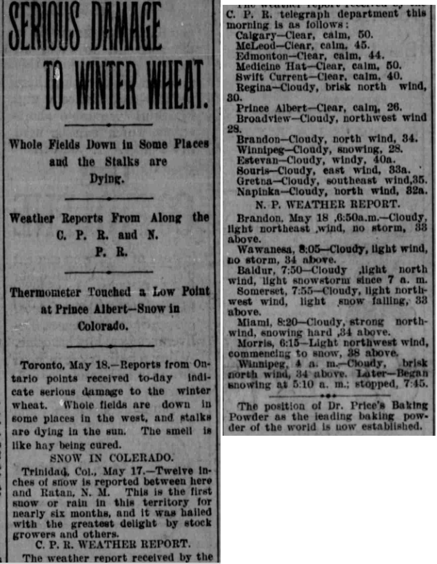
May 18, 1895 Snowfall
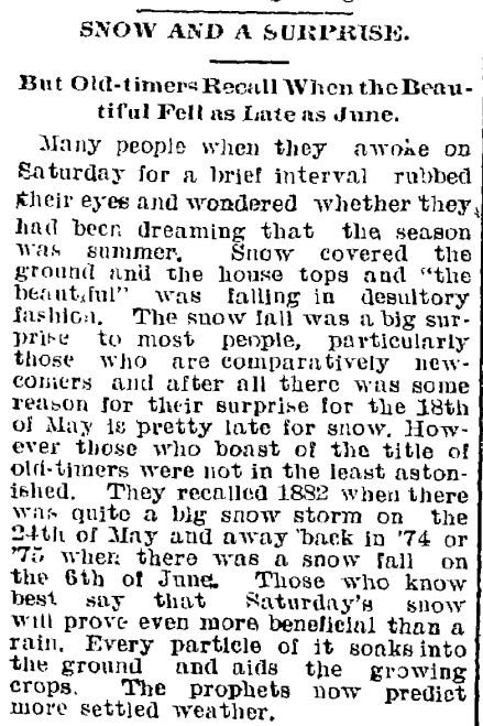
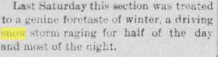
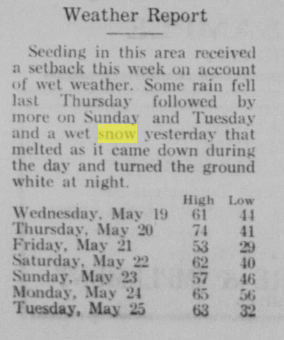
A late snowfall occurred on Saturday May 18, 1895 with 1.5 cm of snow at Winnipeg's St John's College station downtown from 5:10am to 7:45am. Reports of snow were patchy across southern Manitoba with the highest amounts west of the escarpment. 11 to 15 cm fell in Cartwright, 10 cm in Pilot Mound and Pembina Crossing, 2.5 cm in St Albans, 1.0 cm in Minnedosa and 0.5 cm in Emerson. The Free Press had a report of around 20 cm in the Carberry area as well. The storm brought heavier snows south of the border in Colorado where 30 cm was recorded. It was actually welcomed due to drought. Ontario received snow as well which did damage to winter wheat. Northern Michigan was hit as well, with Negaunee (near Marquette) reporting enough for sleighing.
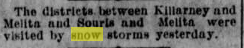
Weather reports from May 18: Baldur - At 7:50am: light snowstorm since 7am, light N wind. Somerset - At 7:55am: light snow falling, 0.6°C, light NW wind. Miami - At 8:20am: Snowing hard, 1.1°C, strong N wind. Morris - At 6:15am: Commencing to snow, light NW wind, 3.3°C. Winnipeg - At 4am: Cloudy, brisk N wind, 1.1°C. Later-began snowing at 5:10am; stopped 7:45am. Brandon - At 6:50am: Cloudy, light NW wind, 0.6°C, no snow. 'Snowstorms' were also reported between Melita and Killarney and Melita and Souris on May 16, a couple days before this event. After the snow, severe frosts occurred for a few nights causing minor damage to crops in northern North Dakota and northwestern Minnesota, and isolated damage in Manitoba. Given the earliness of the season, farmers weren't too concerned. In addition to the newspaper snapshot on the left, other newspaper sources include: Winnipeg Tribune May 18 (page 1), Winnipeg Free Press May 20 (page 1) and May 21 (page 6). |
Winnipeg Free Press Page 6, May 20 1895
|
|
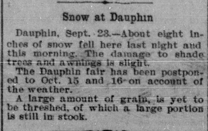
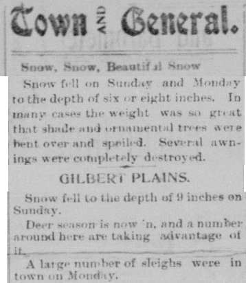
An early snow storm struck the Parklands region of western Manitoba during the overnight and early morning hours of September 23, 1901. Locally, 10 to 20 cm fell. Damage to trees was slight, but some awnings were destroyed in Dauphin by the weight of the wet snow. Elsewhere in southern Manitoba, snow flurries were reported with minimal or no accumulation.
Snowfall reports from newspapers or ECCC Archives Gilbert Plains -- 23 cm Dauphin -- 15 to 20 cm Russell -- 10 cm Shoal Lake -- About 5 cm Minnedosa -- 4 cm Deloraine -- 1.3 cm St Albans -- 0.3 cm Elkhorn -- Trace Winnipeg -- Trace |
Brandon Western Sun, Sep 26 1901 page 1
|
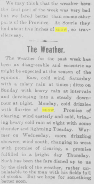
Other reports:
Rossburn -- Snowing, threshing at a standstill
Solsgirth -- Heavy fall of snow
Glenboro -- Flurries of snow
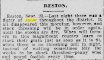
Reston -- Flurry of snow last night. All disappeared this morning.
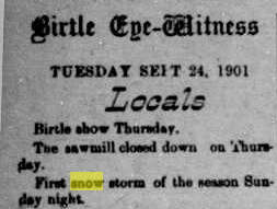
Birtle -- First snow storm of the season
Souris -- Glenboro Gazette mentioned 5 inches (13 cm) according to travellers, but it is unclear which day they are referring to
On the Saskatchewan side, Crescent Lake just south of Yorkton recorded 17 cm.
The snowstorm was the start of a cold week in general. On the Saskatchewan side, two more days of snow occurred on the 25th and 27th. Moosomin SK recorded another 8 cm and 5 cm respectively on these dates. These days remained mostly as rain on the Manitoba side.
Newspaper sources: Dauphin Weekly News Sep 25 (page 1), Birtle Eye Witness Sep 24 (page 4), Dauphin Weekly News Sep 25 (page 1), Glenboro Gazette Sep 27 (page 1), Shoal Lake Star Sep 26 (page 5), Winnipeg Free Press Sep 25 (page 10) and Sep 30 (page 7).
Rossburn -- Snowing, threshing at a standstill
Solsgirth -- Heavy fall of snow
Glenboro -- Flurries of snow
Reston -- Flurry of snow last night. All disappeared this morning.
Birtle -- First snow storm of the season
Souris -- Glenboro Gazette mentioned 5 inches (13 cm) according to travellers, but it is unclear which day they are referring to
On the Saskatchewan side, Crescent Lake just south of Yorkton recorded 17 cm.
The snowstorm was the start of a cold week in general. On the Saskatchewan side, two more days of snow occurred on the 25th and 27th. Moosomin SK recorded another 8 cm and 5 cm respectively on these dates. These days remained mostly as rain on the Manitoba side.
Newspaper sources: Dauphin Weekly News Sep 25 (page 1), Birtle Eye Witness Sep 24 (page 4), Dauphin Weekly News Sep 25 (page 1), Glenboro Gazette Sep 27 (page 1), Shoal Lake Star Sep 26 (page 5), Winnipeg Free Press Sep 25 (page 10) and Sep 30 (page 7).
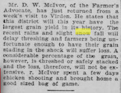
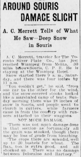
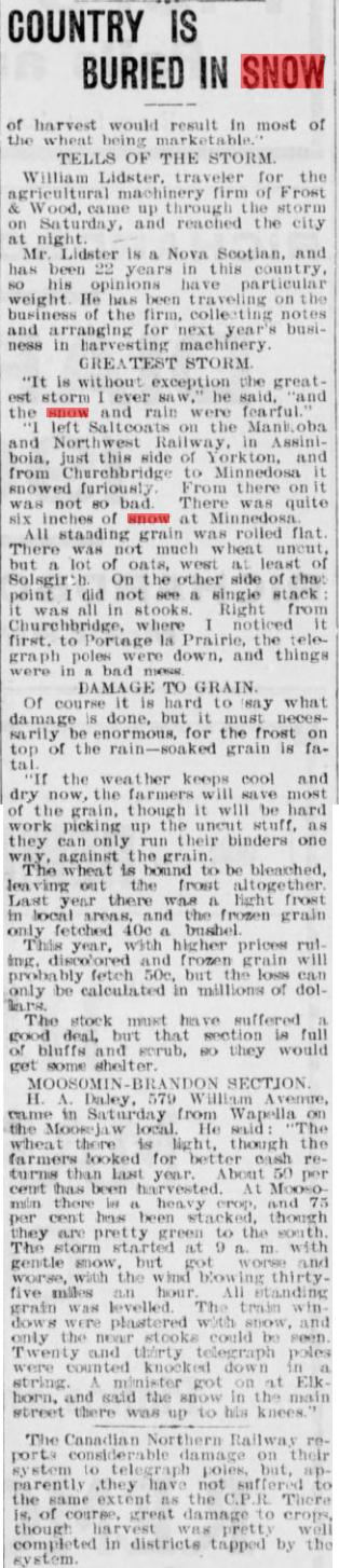
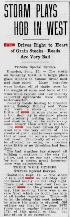
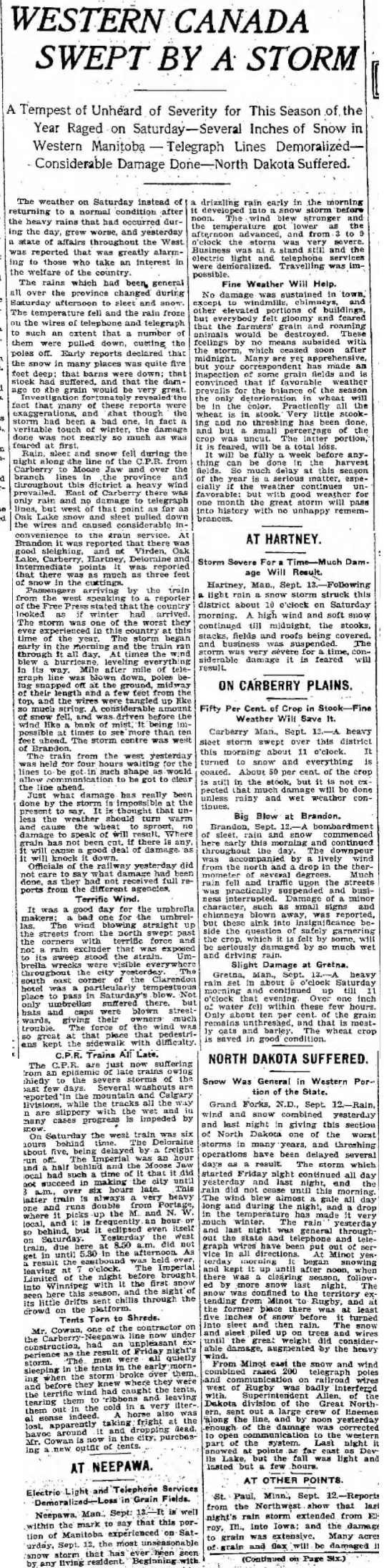
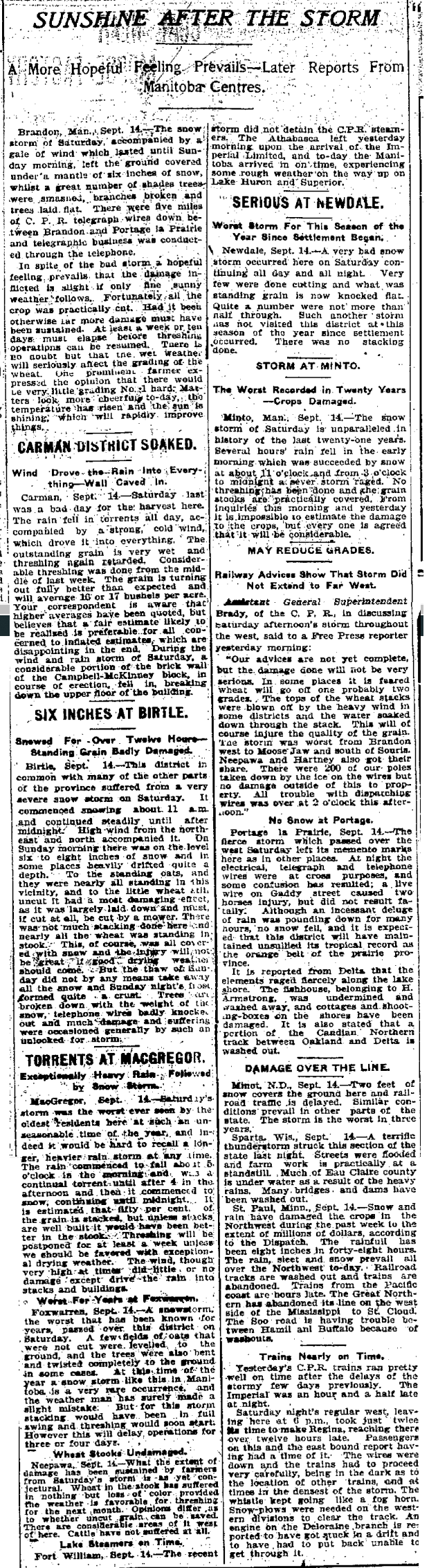
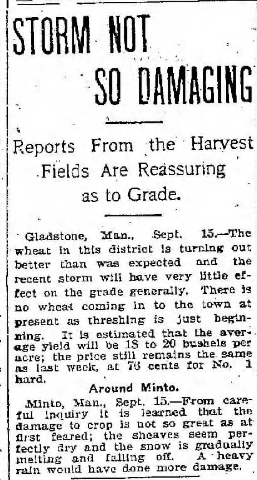
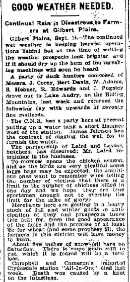
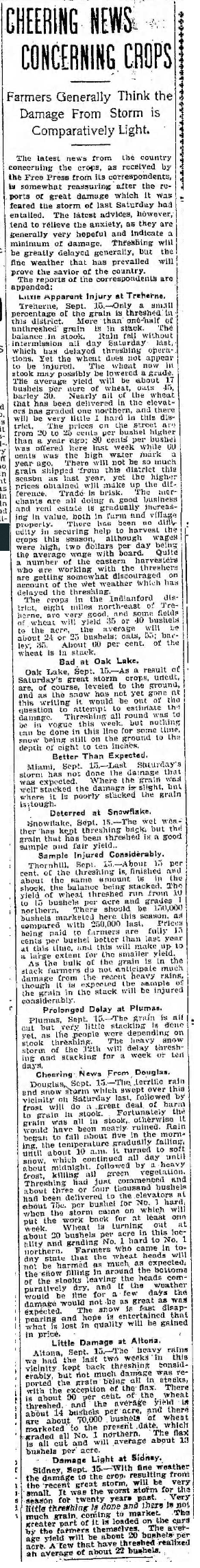
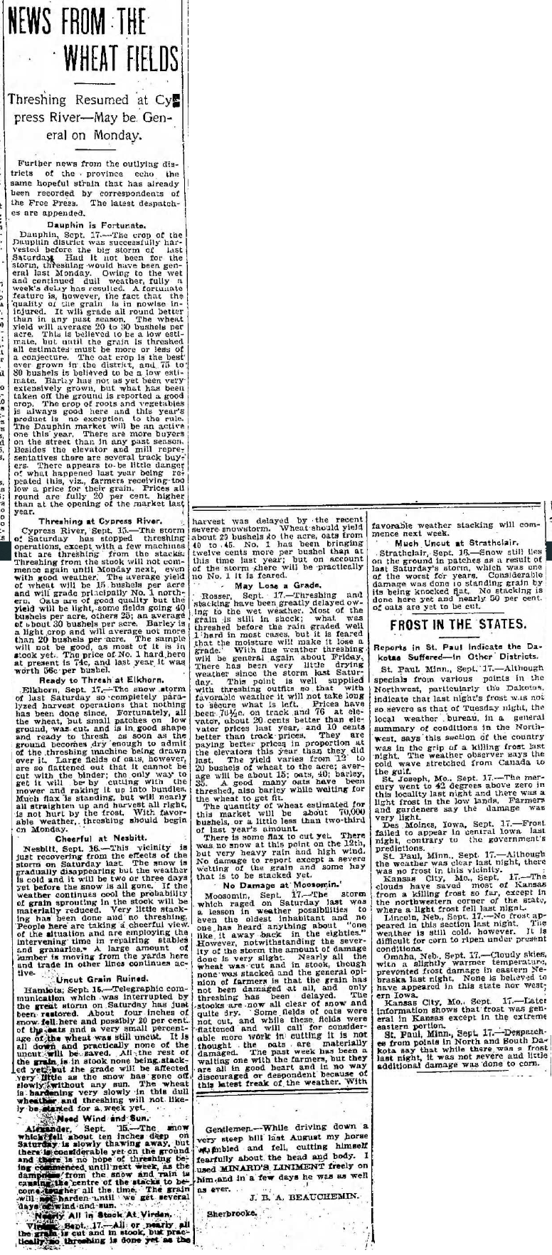
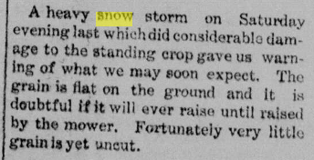
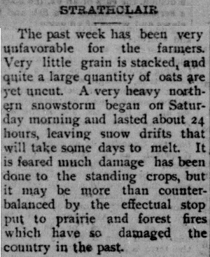
A strong system brought impressive precipitation amounts to southern Manitoba September 12 and 13, 1903. The system produced heavy rains in south-central and southeastern Manitoba, dropping between 40 and 70 mm. In southwestern Manitoba, the system brought one of the worst snowstorms ever recorded that early in the season. Anywhere from 10 to 30 cm fell from the US border to Dauphin. This snow was preceded by heavy rain, and in some spots ice pellets or freezing rain, bringing total system amounts between 30 and 70 mm. The heavy snow flattened unharvested crops. Thankfully, most of the crops had been harvested already and some crops recovered as the snow melted. As a result, damage to crops was much more insignificant than feared. The main impact was a delay in threshing and harvesting by at least a week.
|
Snowfall amounts:
Souris 40 cm (according to A.C. Merrett, a traveller) Hillview 30.5 cm (north of Oak Lake) Rapid City 25.4 cm Alexander 25 cm Deloraine 22.9 cm Turtle Mountain 20.3 cm Baldur 17 to 20 cm Birtle 15 to 20 cm (11am Sep 12 to after midnight Sep 13). Dauphin 15.2 cm Elkhorn 15.2 cm Minnedosa 14.8 cm Gilbert Plains 13 cm Brandon 10.2 cm Hamiota 10 cm Gladstone over 5 cm Norquay 3.8 cm (northwest of Somerset) Russell 2.5 cm Cartwright, Oakbank and Gretna Trace |
Rainfall amounts:
Cartwright 69 mm Almasippi 62 mm (northwest of Carman) Stony Mountain 56 mm Beaver 55 mm (northeast of MacGregor) Norquay 44 mm Turtle Mountain 43 mm Winnipeg 41 mm Gretna 41 mm Oakbank 40 mm Rapid City 34 mm Brandon 20 mm |
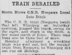
The system also featured strong winds which, combined with wet snow and ice, snapped countless telegraph poles. Drifts over a metre deep made travel difficult. One train was stuck in a nearly two metre drift on the Deloraine track near Minto. A train also derailed a short distance north of Eden as a result of drifts 30 to 90 cm deep (north of Neepawa).
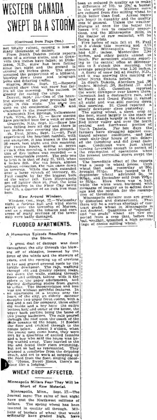
The storm also struck western North Dakota with rain and snow. Dickinson to Minot to Rugby received the most snow. The wet snow did considerable damage to trees and wires. It snowed as far east as Devils Lake, but the fall was light and lasted only a few hours. Colorado and Wyoming were also hard hit with up to 40 cm. In Minnesota, it was largely a rain event. St Paul received over 125 mm of rain, an amount only overtaken by July 27, 1893 there. Over 200 mm fell in 48 hours. Railroad tracks were washed out in places.
At Winnipeg, it was a rain event with over 40 mm. The wind was ''terrific'' from the north, making it difficult to walk around with an umbrella or hat. Trains coming into the city from the west were as much as 6 hours late due to the snowstorm in the west.
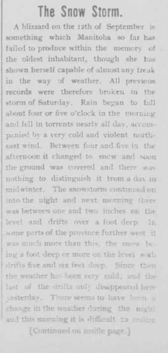
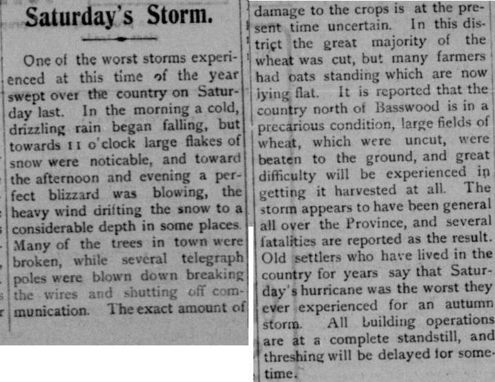
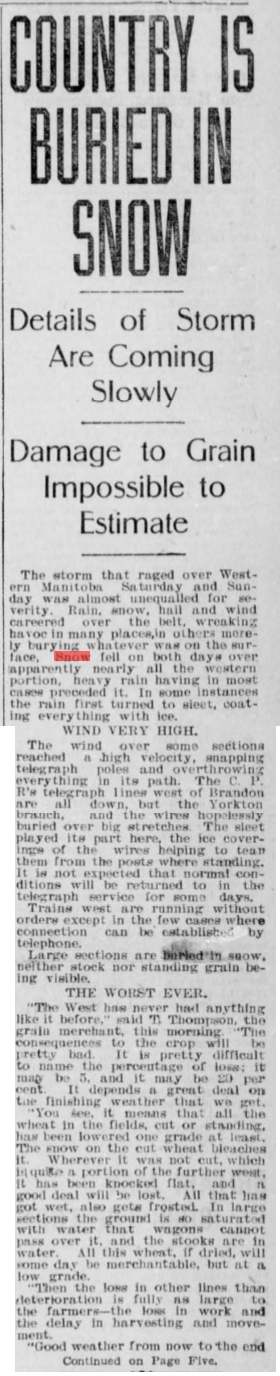
Neepawa - ''The most unseasonable snowstorm ever seen by any living resident''. Drizzling rain developed into a snowstorm before noon on Sep 12. Electric light and telephone services demoralized, travelling impossible.
Carberry - Storm of ice pellets began 11am Sep 12, turning then to snow which covered everything.
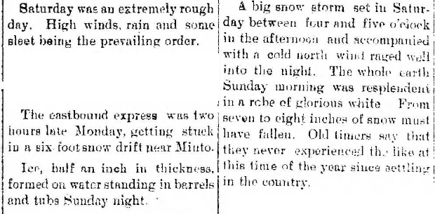
Brandon - Storm of sleet, rain and snow began early morning Sep 12. ''Lively'' north wind causing minor wind damage: small signs and chimneys blown away. Trees were smashed and branches broken by the wet snow and wind.
Gretna - Heavy rain began early morning Sep 12, continuing until 11pm.
Carman - Rain fell in torrents all of Sep 12, accompanied by a strong cold N wind.
Birtle - Some of the snow melted on the 13th but not all. Trees broken down and telephone wires knocked out by the weight of the snow and wind.
MacGregor - The worst storm ever seen by the oldest residents, especially at such an unseasonable time of year. Rain started 5am Sep 12 in a continual torrent until after 4pm when it switched to snow. Continued until midnight.
Foxwarren - Worst snowstorm in years on Sep 12. Unharvested oats levelled to the ground, and trees bent and twisted completely to the ground in some cases.
Newdale - Very bad snowstorm Sep 12 all day and night, the worst since settlement. Standing grain knocked flat.
Minto - Snowstorm unparalleled in 21 years. Several hours of rain early morning Sep 12, succeeded by snow at 11am and a severe storm from 3pm to midnight. Damage to crops was insignificant.
Portage la Prairie - Incessant deluge of rain but no snow.
Delta/south shore of Lake Manitoba - Fishhouse washed away, cottages on the shores damaged. Portion of CNR track between Oakland and Delta washed out.
Treherne - Rain fell without intermission all day Sep 12.
Oak Lake - Uncut crops levelled to the ground. Ground still covered by 20 to 25 cm of snow on the 15th.
Douglas - Rain began about 5am Sep 12, switching to soft snow about 10 am, which continued until midnight. Heavy frost afterwards killed green vegetation.
Nesbitt - Snow still on ground on the 16th, gradually disappearing.
Alexander - Considerable snow remains on the ground on the 15th, slowly thawing.
Baldur - Snow storm set in between 4pm and 5pm Sep 12. Cold N wind raged well into the night. Earth covered in glorious white Sep 13. 17-20 cm must have fallen.
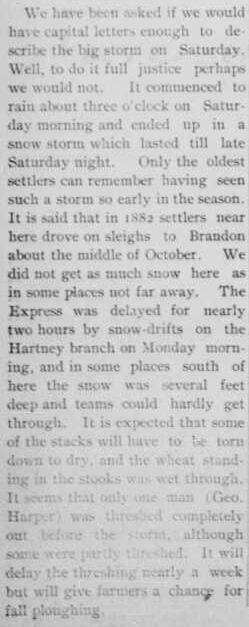
Belmont - Rain began 3am Sep 12, becoming a snowstorm until late in the night the next night. Trains delayed nearly 2 hours by snow drifts. Some places drifts were several feet deep.
Glenboro - Rain began 4 or 5 am Sep 12, falling in torrents nearly all day. Very cold, violent NE wind. Switched to snow 4-5pm, and quickly covered the ground. 2 to 5 cm by the morning but drifts over 30 cm deep. Drifts not melted away until about the 17th.
Rapid City - Cold drizzling rain began in the morning Sep 12, switching to large flakes of snow towards 11am and a perfect blizzard in the afternoon and evening. Snow drifting to a considerable depth. Many trees broken, several telegraph poles blown down. North of Basswood, large fields of wheat which were uncut were beaten to the ground.
Other Newspaper sources: Winnipeg Tribune Sep 14 (page 1 and page 5), Sep 15 (page 11). Winnipeg Free Press Sep 14 (page 1 and page 6), Sep 15 (page 7), Sep 16 (page 1 and page 3), Sep 17 (page 3) and Sep 18 (page 11). Swan River Star Sep 16 (page 1). Russell Banner Sep 17 (page 2 and page 2(b)). Grandview Exponent Sep 18 (page 15).
The storm also struck western North Dakota with rain and snow. Dickinson to Minot to Rugby received the most snow. The wet snow did considerable damage to trees and wires. It snowed as far east as Devils Lake, but the fall was light and lasted only a few hours. Colorado and Wyoming were also hard hit with up to 40 cm. In Minnesota, it was largely a rain event. St Paul received over 125 mm of rain, an amount only overtaken by July 27, 1893 there. Over 200 mm fell in 48 hours. Railroad tracks were washed out in places.
At Winnipeg, it was a rain event with over 40 mm. The wind was ''terrific'' from the north, making it difficult to walk around with an umbrella or hat. Trains coming into the city from the west were as much as 6 hours late due to the snowstorm in the west.
Neepawa - ''The most unseasonable snowstorm ever seen by any living resident''. Drizzling rain developed into a snowstorm before noon on Sep 12. Electric light and telephone services demoralized, travelling impossible.
Carberry - Storm of ice pellets began 11am Sep 12, turning then to snow which covered everything.
Brandon - Storm of sleet, rain and snow began early morning Sep 12. ''Lively'' north wind causing minor wind damage: small signs and chimneys blown away. Trees were smashed and branches broken by the wet snow and wind.
Gretna - Heavy rain began early morning Sep 12, continuing until 11pm.
Carman - Rain fell in torrents all of Sep 12, accompanied by a strong cold N wind.
Birtle - Some of the snow melted on the 13th but not all. Trees broken down and telephone wires knocked out by the weight of the snow and wind.
MacGregor - The worst storm ever seen by the oldest residents, especially at such an unseasonable time of year. Rain started 5am Sep 12 in a continual torrent until after 4pm when it switched to snow. Continued until midnight.
Foxwarren - Worst snowstorm in years on Sep 12. Unharvested oats levelled to the ground, and trees bent and twisted completely to the ground in some cases.
Newdale - Very bad snowstorm Sep 12 all day and night, the worst since settlement. Standing grain knocked flat.
Minto - Snowstorm unparalleled in 21 years. Several hours of rain early morning Sep 12, succeeded by snow at 11am and a severe storm from 3pm to midnight. Damage to crops was insignificant.
Portage la Prairie - Incessant deluge of rain but no snow.
Delta/south shore of Lake Manitoba - Fishhouse washed away, cottages on the shores damaged. Portion of CNR track between Oakland and Delta washed out.
Treherne - Rain fell without intermission all day Sep 12.
Oak Lake - Uncut crops levelled to the ground. Ground still covered by 20 to 25 cm of snow on the 15th.
Douglas - Rain began about 5am Sep 12, switching to soft snow about 10 am, which continued until midnight. Heavy frost afterwards killed green vegetation.
Nesbitt - Snow still on ground on the 16th, gradually disappearing.
Alexander - Considerable snow remains on the ground on the 15th, slowly thawing.
Baldur - Snow storm set in between 4pm and 5pm Sep 12. Cold N wind raged well into the night. Earth covered in glorious white Sep 13. 17-20 cm must have fallen.
Belmont - Rain began 3am Sep 12, becoming a snowstorm until late in the night the next night. Trains delayed nearly 2 hours by snow drifts. Some places drifts were several feet deep.
Glenboro - Rain began 4 or 5 am Sep 12, falling in torrents nearly all day. Very cold, violent NE wind. Switched to snow 4-5pm, and quickly covered the ground. 2 to 5 cm by the morning but drifts over 30 cm deep. Drifts not melted away until about the 17th.
Rapid City - Cold drizzling rain began in the morning Sep 12, switching to large flakes of snow towards 11am and a perfect blizzard in the afternoon and evening. Snow drifting to a considerable depth. Many trees broken, several telegraph poles blown down. North of Basswood, large fields of wheat which were uncut were beaten to the ground.
Other Newspaper sources: Winnipeg Tribune Sep 14 (page 1 and page 5), Sep 15 (page 11). Winnipeg Free Press Sep 14 (page 1 and page 6), Sep 15 (page 7), Sep 16 (page 1 and page 3), Sep 17 (page 3) and Sep 18 (page 11). Swan River Star Sep 16 (page 1). Russell Banner Sep 17 (page 2 and page 2(b)). Grandview Exponent Sep 18 (page 15).
|
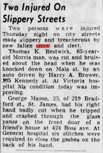
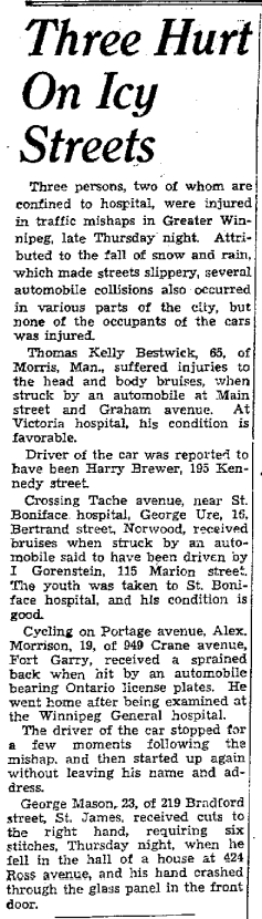
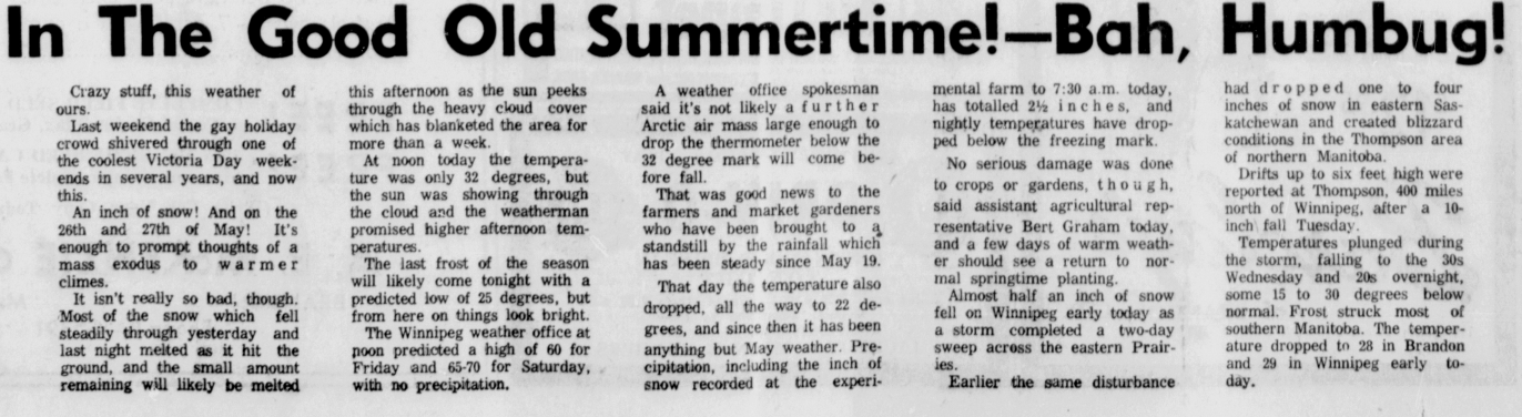
A snowstorm struck southeastern Manitoba on May 5 and 6, 1938. Generally, 5 to 20 cm fell. accompanied by strong winds of up to 60 km/h. Temperatures fell during the day on the 5th as the snow began, with snow mostly melting on roads. However, during the night, the snow accumulated quickly. Roads and sidewalks became slippery, with injuries reported due to vehicle accidents and pedestrian falls. Some flight delays occurred as well. It appears Winnipeg was on the edge of the storm system, as downtown recorded up to 18 cm, and the Airport only 8 cm.
The storm also hit parts of Minnesota, with heavy snow in Duluth which resulted in the cancellation of a baseball game the Winnipeg Maroons were scheduled to play there. Sprague 22.8 cm Winnipeg St John's College 18.1 cm Great Falls 10.1 cm Winnipeg Airport 8.4 cm Pinawa 8.4 cm Indian Bay 6.4 cm Moosehorn 1.8 cm Brandon, Minnedosa and Emerson Trace Newspaper sources: Winnipeg Tribune May 6 (page 1 - includes the snippet on the right and page 3) and May 5 (page 1), Winnipeg Free Press May 7 (page 3 and page 22), Brandon Daily Sun May 6 (page 1) |
|
|
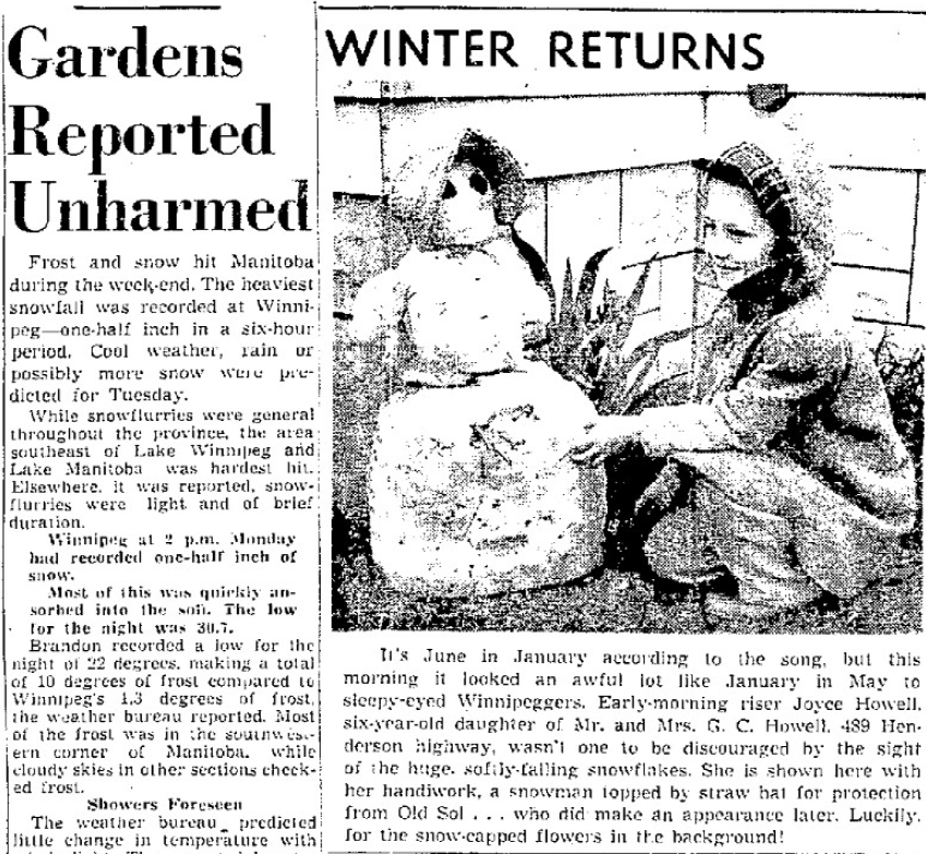
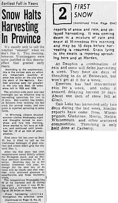
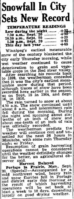
Winnipeggers awoke to snow on September 20, 1945. It was the earliest date that measurable snowfall was recorded in the city. 1.5 cm fell at the Airport. The snow began about 4:20am and continued until about 8am when it was followed by intermittent rain. Most of southern Manitoba experienced some snow flurries.
Berens River 7.6 cm Gimli 2.5 cm (according to the Tribune - ECCC Archives have trace) Winnipeg Airport 1.5 cm Emerson, Minnedosa, St Albans and Rivers Trace Portage la Prairie and Dauphin had snow according to newspapers, no amounts available in ECCC Archives The cold wet weather put a damper on harvest operations, which were already delayed. Newspaper sources: Winnipeg Tribune Sep 20 (page 1 and 12). Winnipeg Free Press Sep 20 (page 1). |
Winnipeg Tribune Sep 20 page 1
|
|
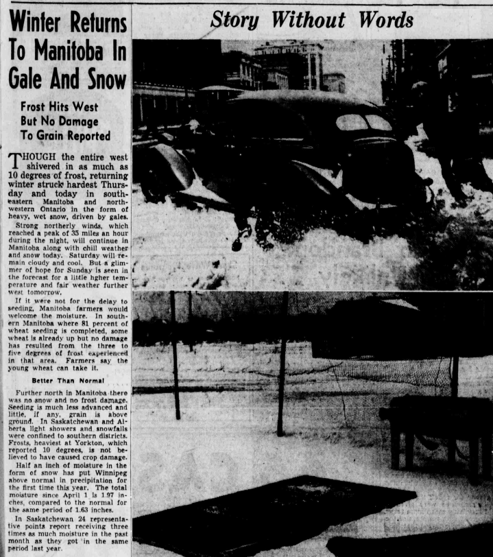
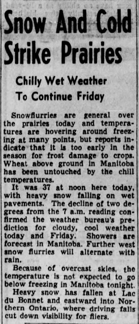
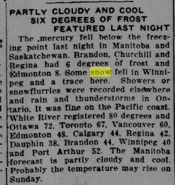
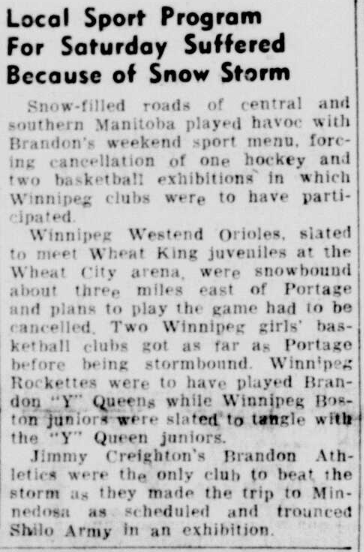
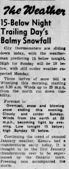
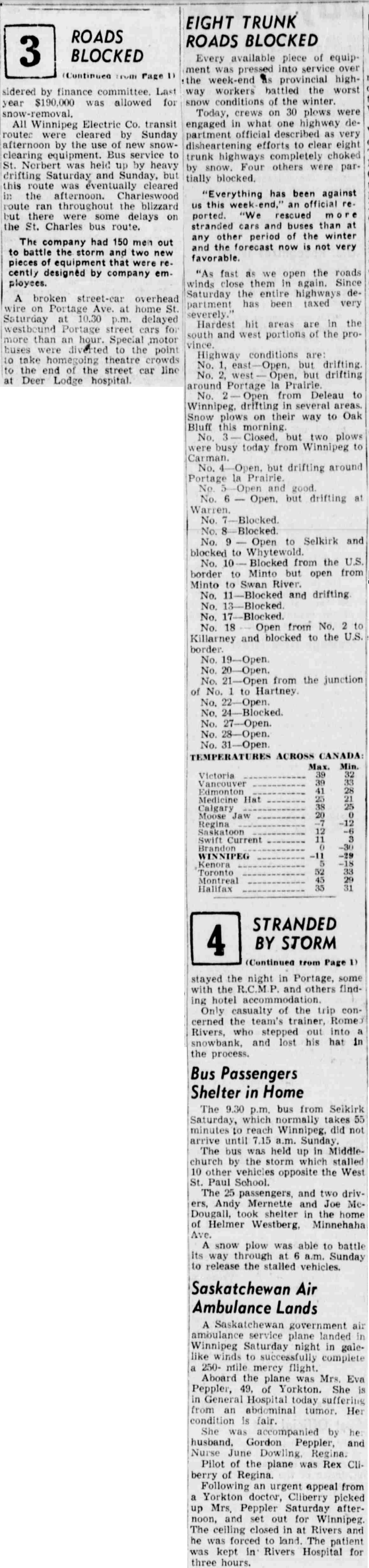
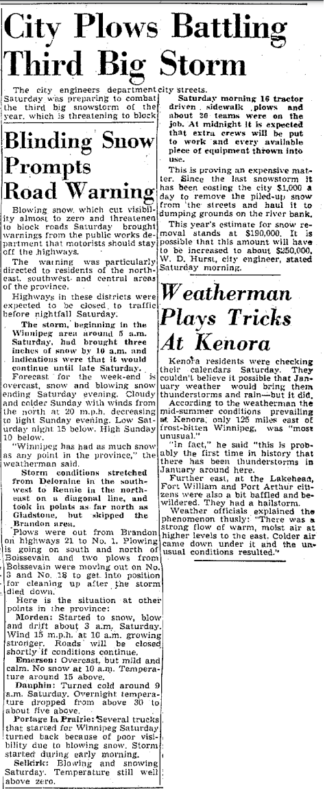
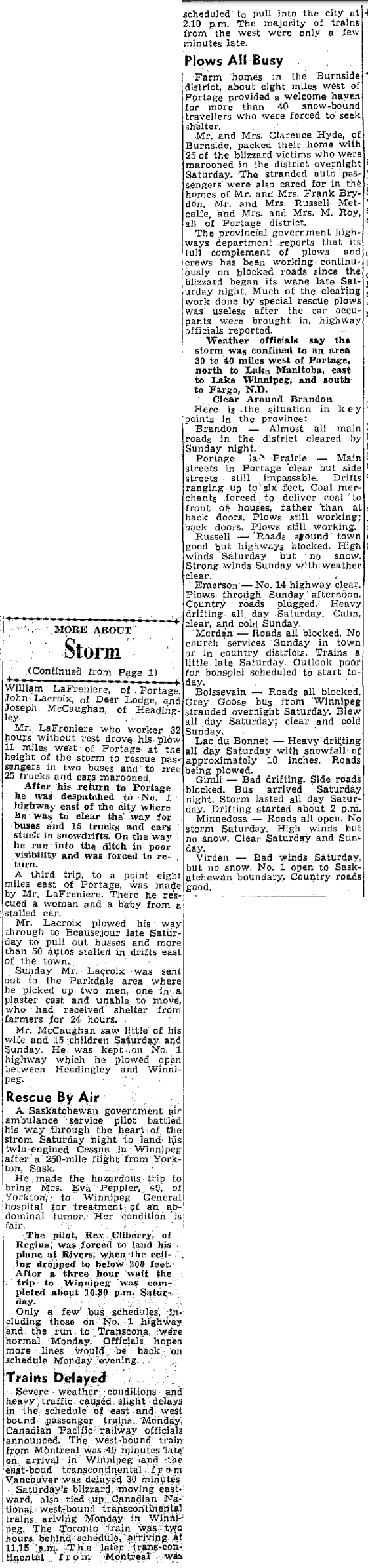
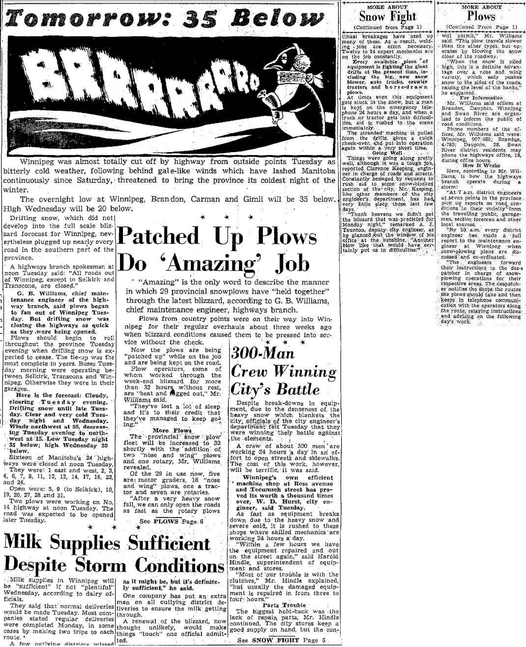
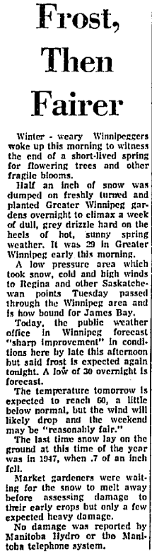
A snowstorm dumped a general 15 to 25 cm in south-central Manitoba, from Deloraine and Morden, to Winnipeg and Selkirk, and to Bissett and Pinawa on January 15, 1949. The system even brought rare January thunderstorms in northwestern Ontario with Kenora recording a thunderstorm with freezing rain. Thunder Bay reportedly had a hailstorm. In Winnipeg, snow began at 530am and accumulated to 19 cm at the Airport by the storm's end. Moderate winds produced some blowing and drifting snow. It was the third significant snowstorm of the winter. Earlier storms in mid December and early January had each dumped around 25 cm in Winnipeg.
Lac du Bonnet 25 cm (approximately) -- heavy drifting all day. Altona 23 cm Pinawa 22 cm Great Falls 20 cm Cypress River 20 cm Winnipeg Airport 19 cm Morden 19 cm -- Snow and blowing snow started about 3 am. Roads all blocked. Bissett 15 cm Portage la Prairie 10 cm -- Storm started early morning Sprague 5 cm Emerson 5 cm -- No snow had fallen yet up to 10 am. Heavy drifting all day. The storm caused travel issues. Drifts reportedly reached as high as 3 metres, blocking some roads and highways. Some sports teams had started their travel to Brandon for exhibitions but ended up stranded around Portage. Some trucks which had left from Portage turned around on their way to Winnipeg due to poor driving conditions. Fuel and milk deliveries were crippled. Tow truck companies were very busy as cars became stuck. Some stranded motorists on the Trans Canada were provided shelter by local farm houses outside Portage. Newspaper sources: Winnipeg Tribune Jan 15 (page 1) and Jan 17 (page 1 -- seen on the right -- and page 8), Winnipeg Free Press Jan 15 (page 3) and Jan 17 (page 1 and page 6) |

|
|
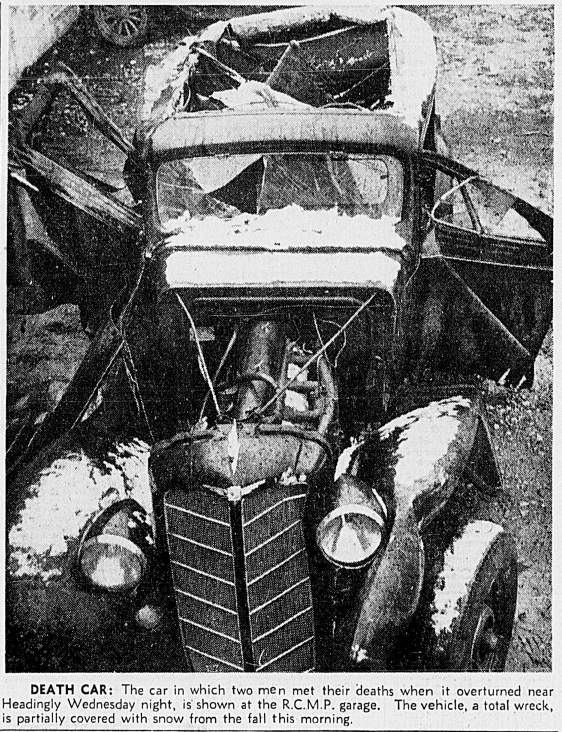
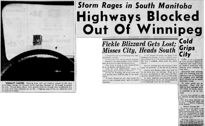
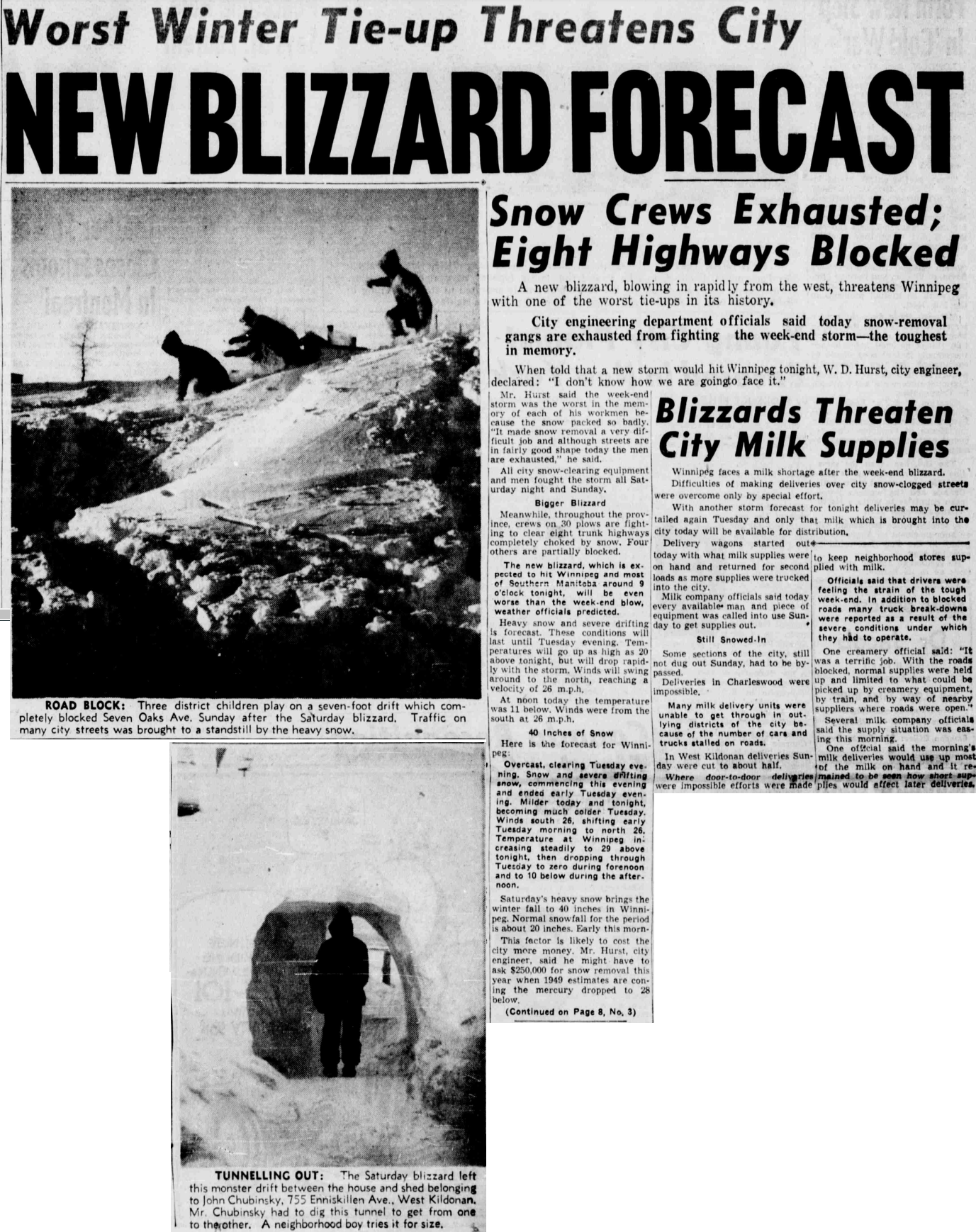
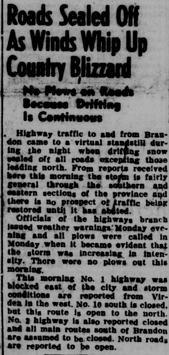
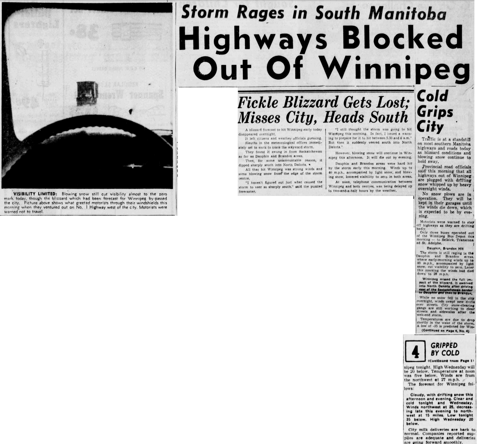
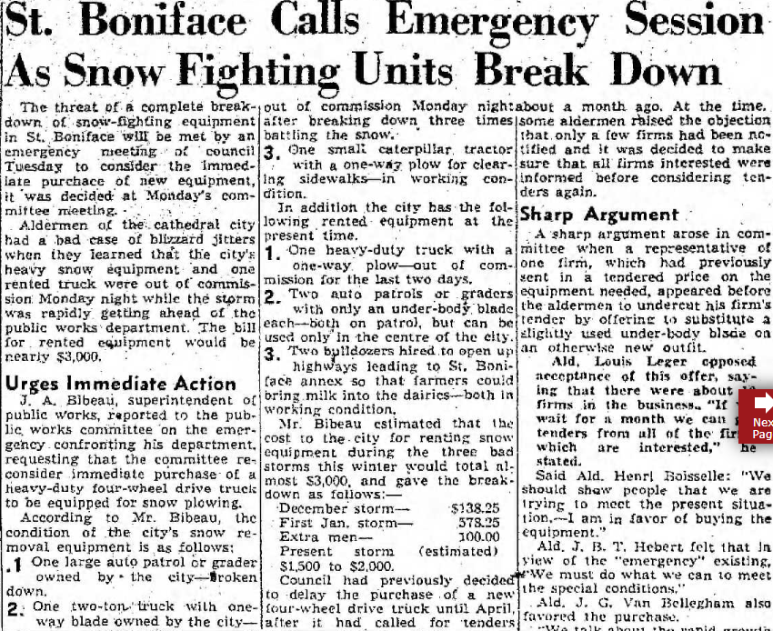
Just three days after a nasty blizzard, a clipper system brought more nasty weather on January 18th. The storm was forecast to hit Winnipeg with a significant blizzard, but instead moved through southwestern Manitoba, sparing the city the worst. Winds were still strong, causing significant blowing snow which closed several highways. In fact, all highways out of Winnipeg, except those to Selkirk and Transcona, were closed. Plows could not keep up with the blowing snow which carved out large drifts. As a result, they were not out until winds died down later in the day.
Southwestern Manitoba was reportedly worst hit by this latest storm with near-zero visibility. Winds reached over 60 km/h in the early morning hours. Only light snow fell. Newspaper sources: Brandon Daily Sun Jan 18 (page 1), Winnipeg Tribune Jan 18 (page 1 and 4 -- as seen in photo on the right) and Winnipeg Free Press Jan 18 (page 1 and 6 and page 8) |
|
|
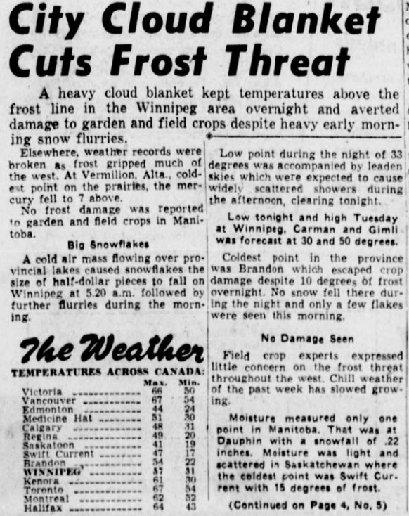
Snow flurries fell in the morning hours of May 23, 1949. Snowflakes were reportedly the size of half-dollar pieces in Winnipeg at 5:20am when the snow began. Flurries continued the remainder of the morning. 2.6 cm of snow was recorded at the Airport (although newspapers only mentioned half an inch, or 1.3 cm, making me wonder if the double entry of 1.3 cm in the Archives is erroneous - I cannot confirm this). Other amounts in MB included:
Dauphin 2.3 cm Gimli 0.3 cm Apparently, the heaviest snowfalls were recorded southeast of Lake Winnipeg and Lake Manitoba, perhaps due to some lake enhancement. Elsewhere, flurries were light and brief. The snow did not seem to do much damage to growing crops and plants. Newspaper sources: Winnipeg Free Press May 23 (page 1), Winnipeg Tribune May 23 (page 1). |
|
|
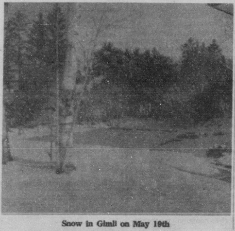
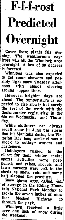
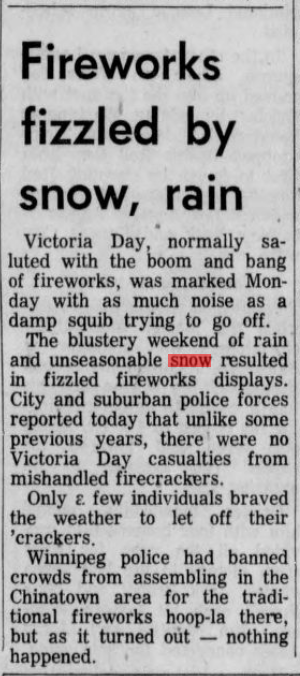
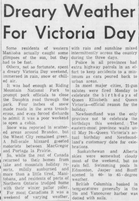
The May Long Weekend of 1963 was one of the most unpleasant on record with snowfall. Snow began in the afternoon of Saturday May 18th and continued until the early morning of the 19th. The snow fell mostly in south-central, southeastern and Interlake regions of Manitoba with 2 to 9 cm. The cold, windy and snowy conditions made for unpleasant camping and cottaging. People huddled around fireplaces and stoves instead of hanging out on the beach. Slippery conditions also resulted in several minor crashes in Winnipeg. The snowy weekend also led to the cancellation of some Victoria Day celebrations and fireworks.
Gimli 9.1 cm Petersfield 8.6 cm Winnipeg Charleswood 7.9 cm Ashern 7.6 cm Dugald 7.6 cm Indian Bay 7.6 cm Ste Genevieve 7.6 cm Eriksdale 7.4 cm Beausejour 5.1 cm Steinbach 5.1 cm Arborg 4.6 cm Winnipeg Airport 4.0 cm Winnipeg St Boniface 3.8 cm Morris 3.6 cm Sprague 3.3 cm Deerwood 3.0 cm Plum Coulee 2.8 cm Portage la Prairie 2.5 cm Stonewall 2.5 cm Emerson 2.5 cm Newspaper sources: Winnipeg Tribune May 20 (page 15 - includes photo above), Winnipeg Free Press May 20 (page 1). Arborg Lake Centre News May 24 (page 1 - includes photo on the right from Gimli). |
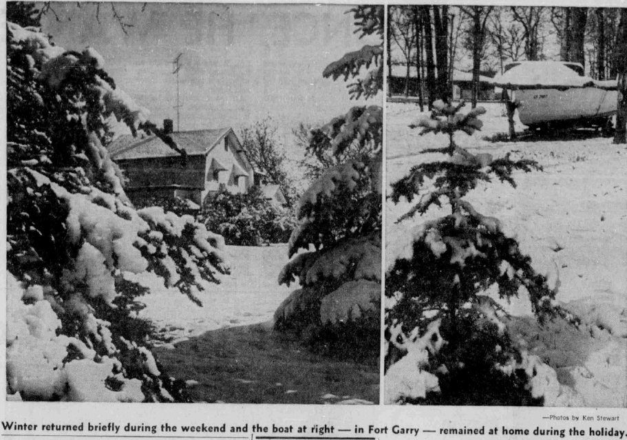
Morning of Sunday May 19, 1963 at Fort Garry, Winnipeg

|
|
More snow fell on Monday May 20th, 1963, making for snow on every day of the May Long Weekend. The snow mostly melted on contact with only less than a centimetre. The snow was accompanied by very strong winds gusting up to 95 km/h, making for a brutally cold afternoon for the time of year. The snowy weekend led to the cancellation of some Victoria Day celebrations and fireworks.
Heavier snows fell in the Parklands region of western Manitoba on the 20th. The higher elevations of Riding Mountain received the most snow with up to 16 cm. Dauphin received 4.6 cm, Plumas 4.3 cm and Rossburn 2.3 cm. Snow plow operators were caught by surprise and forced to take machinery out of storage to clear out Highway 10 in Riding Mountain which was blocked by the snow. The impact of the snows on agriculture was mixed. Some actually benefitted from the moisture and the snow also reduced damage by frost in some areas. Newspaper sources: Winnipeg Free Press May 20 (page 1) and May 21 (page 1). Winnipeg Tribune May 21 (page 17 - see snapshot on the right). Brandon Sun May 21 (page 3). Dauphin Herald and Press May 22 (page 9). |

|
|
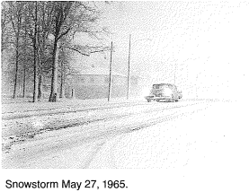
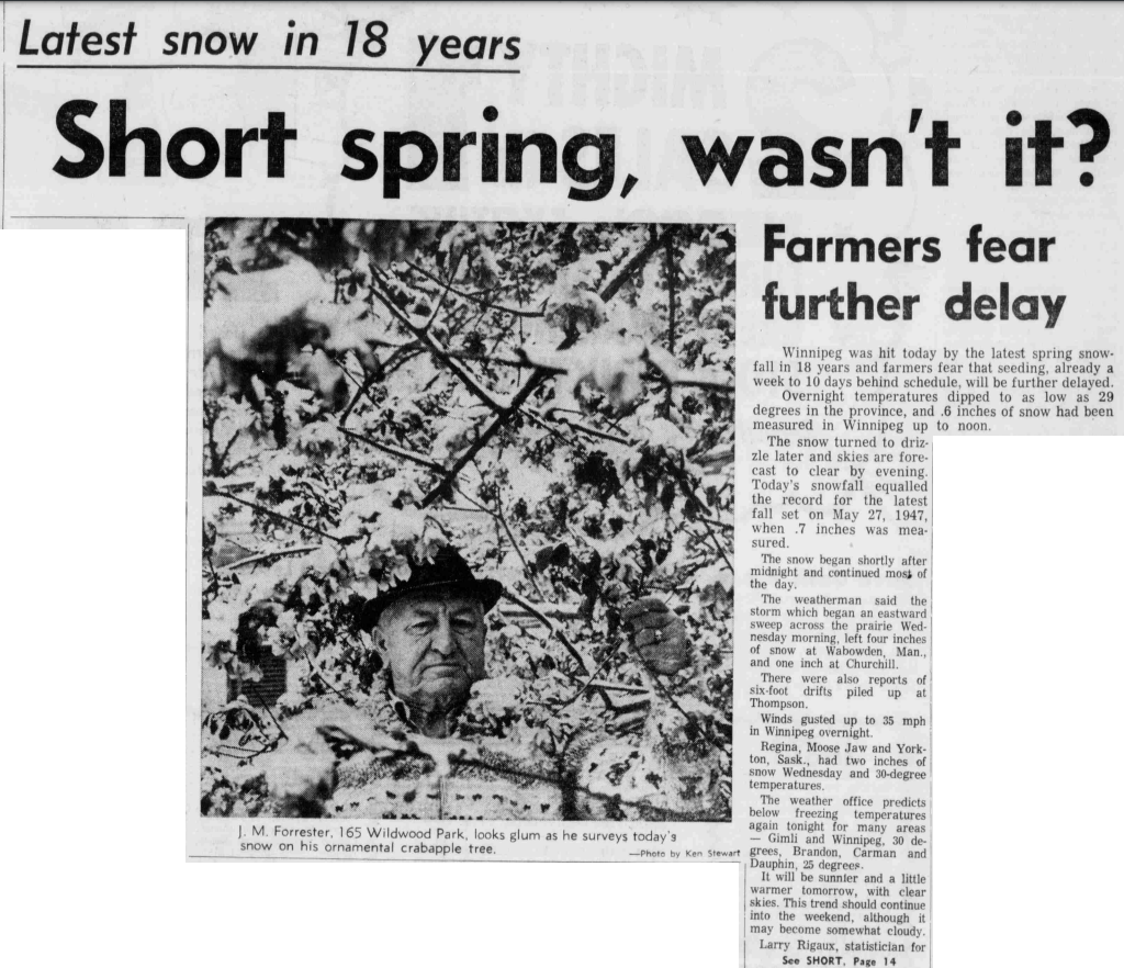
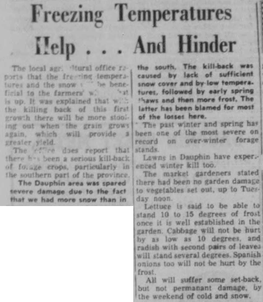
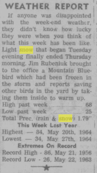
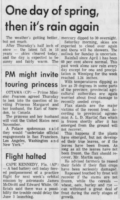
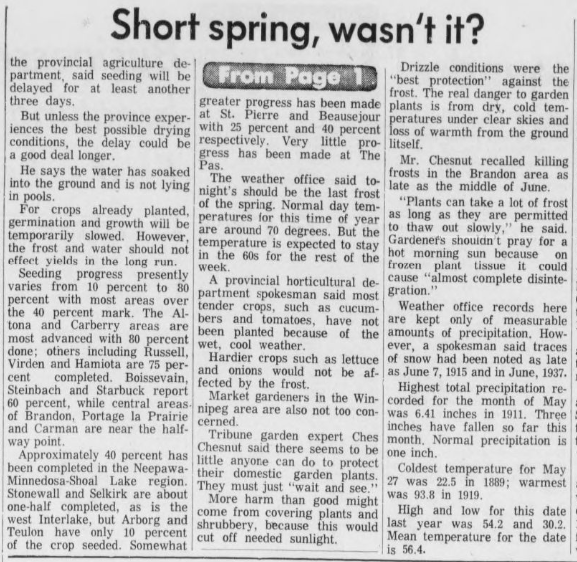
It was a rude awakening on May 26th and 27th, 1965 in southern Manitoba, with snow and below freezing temperatures. 1.3 cm fell at Winnipeg Airport. The last time snow had fallen that late in the season in Winnipeg was in 1947. The daytime high of 3.9°C on the 27th was the coldest for so late in the season.
Snowfall amounts: Riding Mountain 18.8 cm Dauphin 11.4 cm Shilo 10.2 cm Brandon Airport 8.8 cm (though only 3 cm reportedly accumulated - rest melted on contact) Rivers 7.6 cm Carberry 7.1 cm Deerwood 6.9 cm Birtle 6.7 cm Rossburn 5.6 cm Eriksdale 5.1 cm Souris 5.1 cm Ashern 4.6 cm Gimli 4.1 cm Brandon Experimental Farm 4.0 cm Emerson 4.0 cm Morden 3.8 cm Neepawa 3.8 cm Pine Falls 3.0 cm Plum Coulee 2.6 cm Portage Southport 2.6 cm Pilot Mound 2.1 cm Steinbach 1.6 cm Winnipeg Airport 1.3 cm Altona 1.3 cm Rapid City - snow melted on contact the 26th but ground turned white at night |
From: Winkler, a Proud Heritage
|
The system had also brought a significant snowstorm to northern Manitoba, with 13.5 cm at Wabowden south of Thompson and 14.4 cm in The Pas. Apparently, drifts six-feet deep (over 1.5 m) occurred at Thompson as blizzard conditions combined with 25 cm of snow. Saskatchewan was also hit, with 13 cm at Regina, 8 cm at Moose Jaw and 4 cm at Yorkton.
The cold weather damaged some crops sensitive to frost, such as flax. The Rossburn Review reported that some birds were frozen in the storm there, and some took birds indoors to warm up.
Newspaper sources: Winnipeg Tribune May 28 (page 1) and May 27 (page 1 - seen on the right, and page 11). Winnipeg Free Press May 27 (page 1). Brandon Sun May 27 (page 1). Rapid City Reporter May 27 (page 1).
|
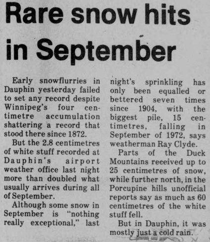
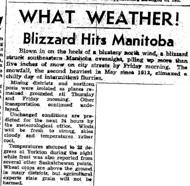
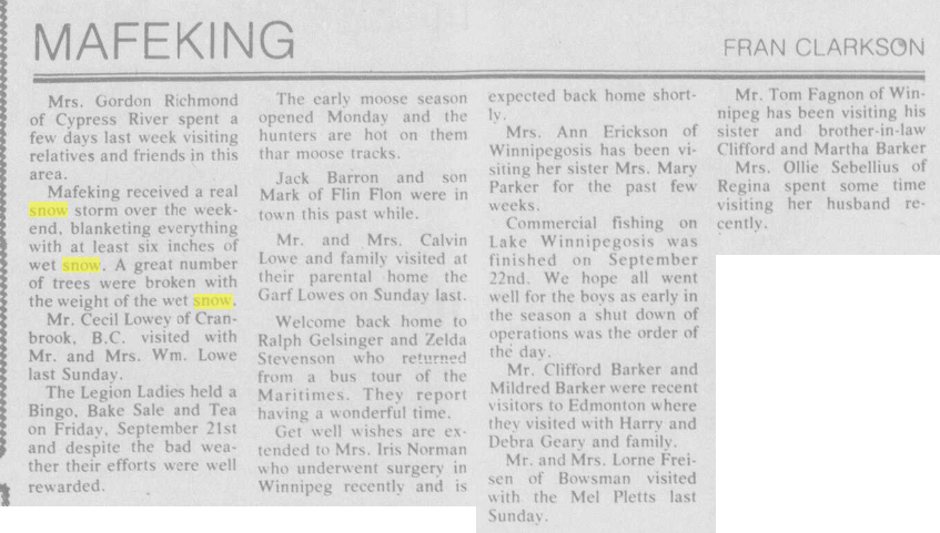
A significant early-season snowstorm struck western and northern Manitoba September 21 and 22, 1984. More than 20 cm of snow fell. Locally higher amounts were recorded in higher elevations of the Duck Mountains and Porcupine Provincial Forest north of Swan River. The Porcupine Hills in eastern Saskatchewan reportedly had as much as 60 cm. The heavy wet snow caused some trees to collapse under the weight. (Swan Valley Star and Times Sep 27 page 6).
Snowfall amounts: Mafeking 28.0 cm Duck Mountains 25 cm (from Dauphin Herald - as seen on the right) Birch River 23.0 cm (northeast of Swan River) The Pas 15.0 cm Swan River 11 to 13 cm Rorketon 7.0 cm Further south toward Dauphin, the precipitation fell as rain with over 20 mm. |
|
|
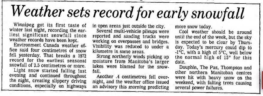
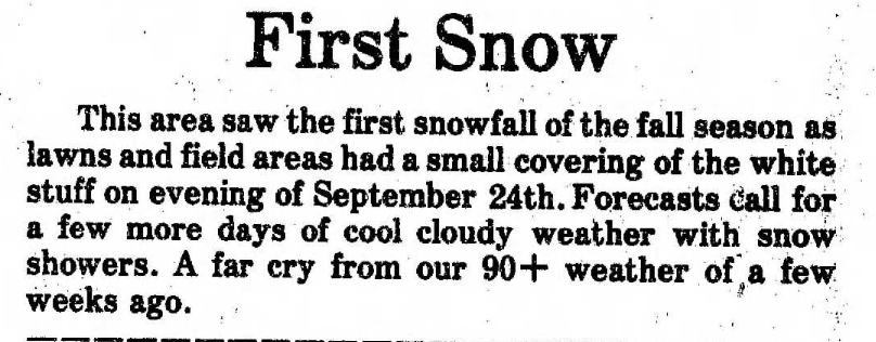
Snow began in the evening of September 24, 1984 and continued until the next morning. 6.6 cm fell at Winnipeg Airport, making it the earliest in the fall on record to receive that much snow.
The snow made roads slippery, especially highways. Several multi-vehicle crashes occurred. Sanding trucks worked on overpasses and bridges. Some areas outside Winnipeg saw visibility drop below a kilometre in heavier snow bands which had developed off the lakes in the northerly wind. Portage la Prairie was hardest hit by these snow bands, with 14 cm of snow in a matter of a few short hours. Visibility was down to 400 metres at Portage Southport. |
|
Snowfall amounts:
Portage Southport 14.4 cm
Gimli 8.4 cm
Turtle Mountain 2 to 7 cm
Winnipeg Airport 6.6 cm
Stony Mountain 6.0 cm
Pinawa 5.2 cm
Russell 5.2 cm
Lake Dauphin 5.0 cm
Dauphin 3.4 cm
Elm Creek 3.2 cm
Morden 3.2 cm
Steinbach 2.3 cm
Baldur 1.6 cm ''a small covering on lawns and fields, the first of the season'' (Baldur Gazette).
Brandon Experimental Farm 1.5 cm
Emerson 1.4 cm
Brandon Airport 0.9 cm
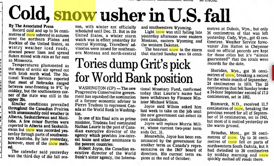
South of the border, heavy snowfall also hit Wyoming, Montana and the western Dakotas. Snow was reported as far east as Minnesota. Over 30 cm fell in parts of Wyoming and Montana. Bismarck, ND received 12 cm, making it its snowiest September on record at the time. The snow in these regions began on the 23rd.
Newspaper sources: Winnipeg Free Press Sep 25 (page 1 - pictured above, and page 65). Lac du Bonnet Leader Oct 2 (page 10).
Portage Southport 14.4 cm
Gimli 8.4 cm
Turtle Mountain 2 to 7 cm
Winnipeg Airport 6.6 cm
Stony Mountain 6.0 cm
Pinawa 5.2 cm
Russell 5.2 cm
Lake Dauphin 5.0 cm
Dauphin 3.4 cm
Elm Creek 3.2 cm
Morden 3.2 cm
Steinbach 2.3 cm
Baldur 1.6 cm ''a small covering on lawns and fields, the first of the season'' (Baldur Gazette).
Brandon Experimental Farm 1.5 cm
Emerson 1.4 cm
Brandon Airport 0.9 cm
South of the border, heavy snowfall also hit Wyoming, Montana and the western Dakotas. Snow was reported as far east as Minnesota. Over 30 cm fell in parts of Wyoming and Montana. Bismarck, ND received 12 cm, making it its snowiest September on record at the time. The snow in these regions began on the 23rd.
Newspaper sources: Winnipeg Free Press Sep 25 (page 1 - pictured above, and page 65). Lac du Bonnet Leader Oct 2 (page 10).
