Historical Thunderstorm Events
|
''A Million Dollar Rain'' drenched Winnipeg and other parts of southern Manitoba on Friday July 9, 1937. It was dubbed this name because of a generally dry year. Winnipeg's St John's College station received 33.5 mm of rain. Other amounts included 26.2 mm in Brandon, 23.9 mm in Sprague. 19.8 mm in Pinawa and 18.3 mm in Stony Mountain. The rains lasted 6 or 7 hours. Unfortunately, the areas hardest hit by the continued summer drought in southern Saskatchewan and western Manitoba (Parklands area) did not receive any rain.
Brandon: A steady, soaking downpour lasted most of the forenoon. Heavy clouds gave the moisture ample time to soak into the ground. Fields and gardens freshened up. Selkirk: An inch (25.4 mm) of rain fell. Morden: Began on the 8th at 11pm and continued 7-8 hours until nearly 7am, piling up to 1.10 inches (27.9 mm). Emerson: 1 inch (25.4 mm). Rain started at 10pm the 8th and stopped at 7am. Neepawa: Still raining the morning of the 10th after heavy rain during the night. Lyleton: The 8th and during the night, 1 inch (25.4 mm). Gimli: 7 hours of rain made crops prospects very good. Winnipeg Beach: Steady rain started at noon, ongoing at 8pm. Fear of a washout on the C.N.R. main line between Wade and Malachi, about 85 miles east of Winnipeg, stopped the Continental Limited there early morning on the 10th. The track was not washed out, but rising waters threatened sufficiently for the train to stop. It arrived in Winnipeg at 12:40pm, 3h40m late. From Winnipeg eastward to Beausejour. Man., a torrential downpour fell. Starting lightly at about 7 p.m., the cloudburst increased to an intensity ''rarely experienced in Winnipeg''. Streets and basements of businesses flooded along Portage and Main. Heavy hail accompanied the downpour in East St. Paul, but no damage was reported and market gardeners rejoiced in the welcome moisture. Household lights flickered momentarily about 10pm, in Winnipeg, but there was no break in the power. Neither telegraph nor telephone companies reported any damage or line interruptions. |
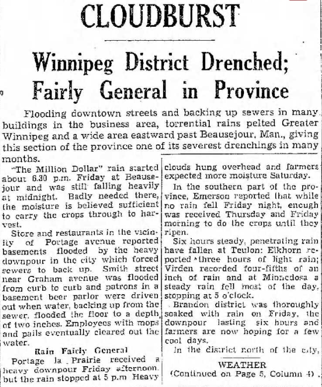
Winnipeg Free Press page 1, Saturday July 10 1937
|
|
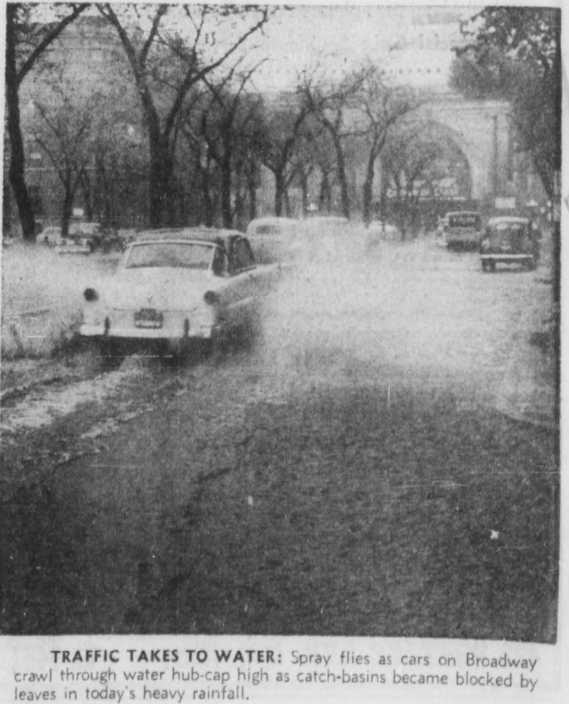
Heavy thunderstorms rolled through for several hours in the overnight and morning hours of Oct 5, 1955. Winnipeg Airport recorded thunderstorms during 5 hours.
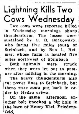
The heavy rain accompanied by the storms caused some street and basement flooding, which was worsened by leaves blocking drains. This caused some traffic delays. On the right is a photo of Broadway Ave with Union Station in the background. All of Broadway Avenue from Memorial Blvd to Kennedy St was under water due to blocked drains. Winnipeg Airport recorded 22 mm of rain. However, the downtown area received the most rain, with 30 to 55 mm: St Boniface 55 mm Clare Ave 54 mm Flora Ave 40 mm Sherburn St 38 mm Sherbrooke St 36 mm Winnipeg Airport 22 mm Other amounts outside Winnipeg included Seven Sisters Falls with 44 mm, Beausejour 38 mm and Emerson 32 mm. Lightning was also problematic. A barn filled with grain and roosters near Culross, MB, between Elm Creek and Starbuck, was destroyed by a lightning strike around 3 am. In Winnipeg and Steinbach, some power poles and lines were damaged. Power outages were only temporary. Near Steinbach, two cows were killed by lightning at two different farms. Newspaper sources: Winnipeg Free Press Oct 5 (page 1), Steinbach Carillon Oct 7 (page 1), Winnipeg Tribune Oct 5 (page 1 - including photo on the right). |
|
|
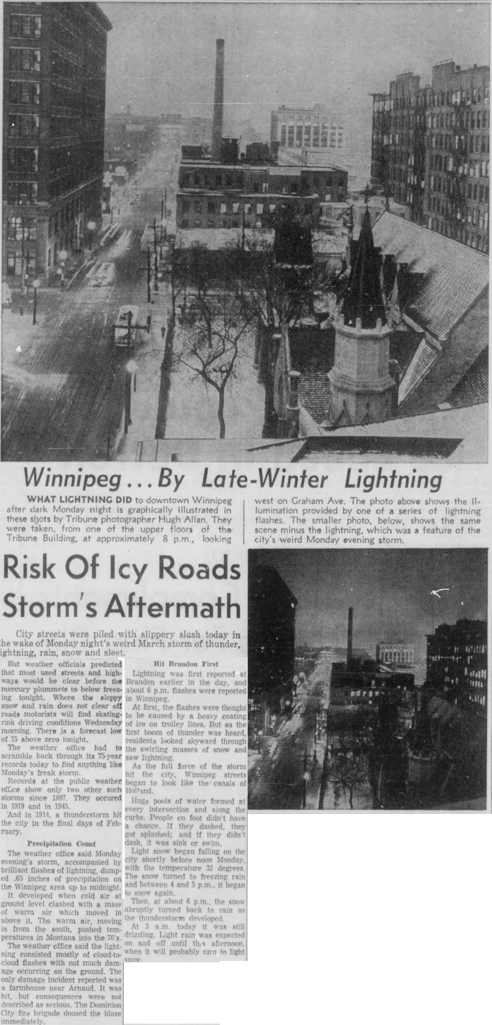
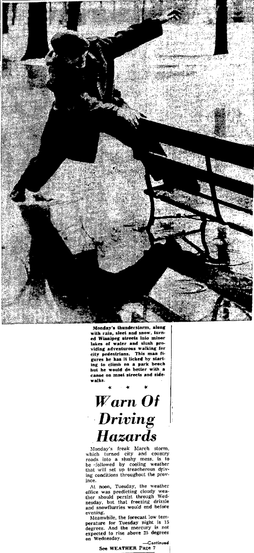
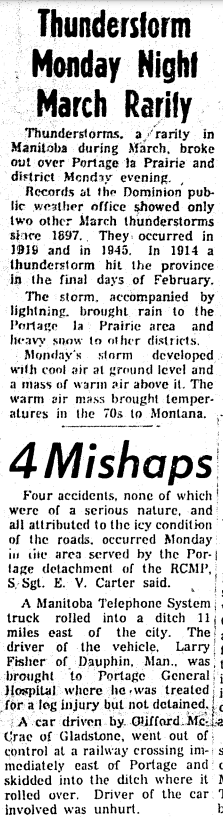
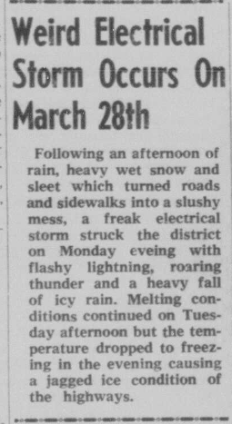
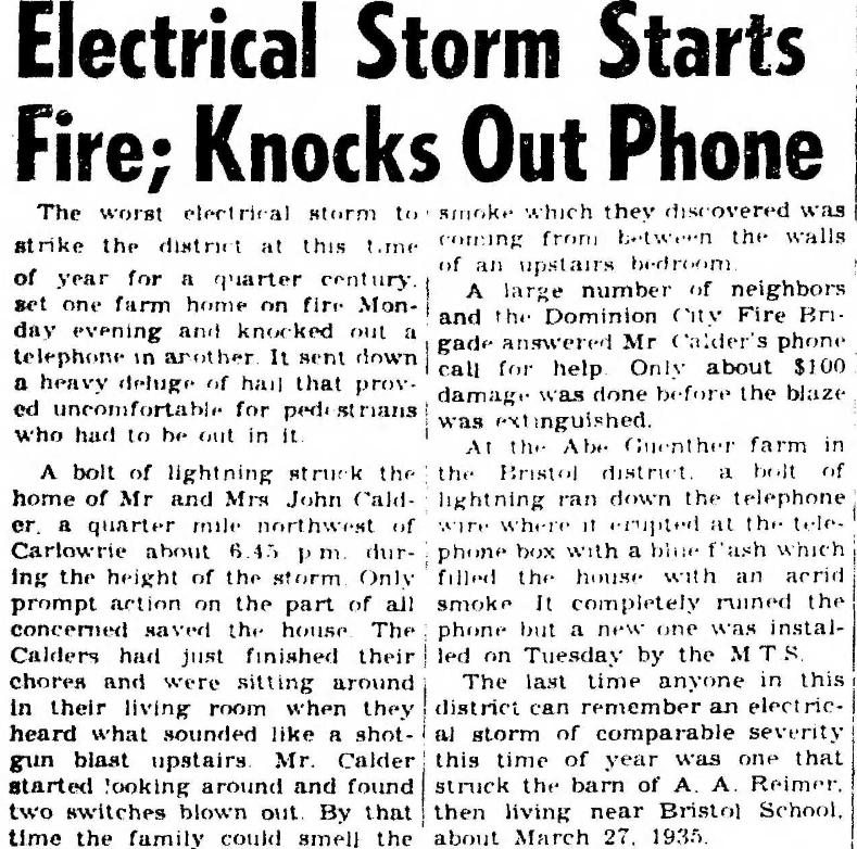
A strong low pressure system brought thunderstorms to much of south-central and southeastern Manitoba in the afternoon and evening hours of March 28, 1960. The storms were described to have developed due to warm air above the surface moving in from the south (warm front aloft and elevated instability). The first reports of lightning were at Brandon earlier in the day. In Winnipeg, snow changed to freezing rain and ice pellets between 4 and 5 pm before switching back to snow again. As the thunderstorm reached Winnipeg about 6 pm, the snow switched to heavy downpours of rain which flooded streets. Temperatures during the storm were only +1°C.
Damage from the storms was minimal. Lightning was described as being mostly cloud-to-cloud. A few cloud-to-ground strikes did occur however, with a home near Arnaud MB being struck. The fire that resulted was quickly extinguished by the Dominion City brigade. Another lightning strike hit a telephone box, causing minor damage to another home. Portage la Prairie, Selkirk and Steinbach all experienced the thunderstorms as well. In the Steinbach area, hail was reported (although maybe it was ice pellets?). The combination of rain, freezing rain, snow and ice pellets throughout the day made sidewalks and roads quite slippery, especially as temperatures fell below freezing during the night. Some vehicles ended up in the ditch west of the city on the highways. Snowfall amounts from the storm were heaviest in northern Manitoba, where 20 to 25 cm fell, such as around The Pas. Gladstone reported 25 mm of rain. Winnipeg Airport reported 15 mm of rain and 2 cm of snow. Newspaper sources: Winnipeg Tribune Mar 29 (page 13 - as on the right). Winnipeg Free Press Mar 29 (page 1 and page 7). Portage la Prairie Leader Mar 31 (page 1). Selkirk Enterprise Mar 30 (page 1). Steinbach Carillon Apr 1 (page 1). |
|
|
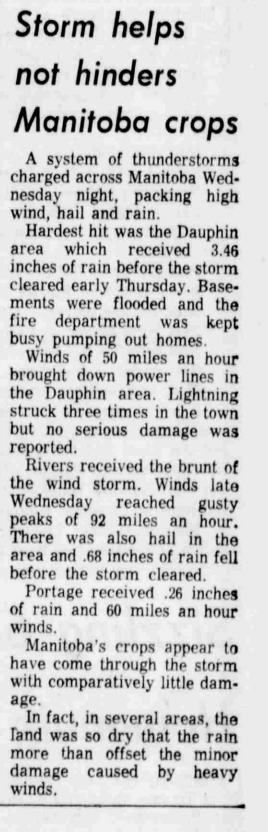
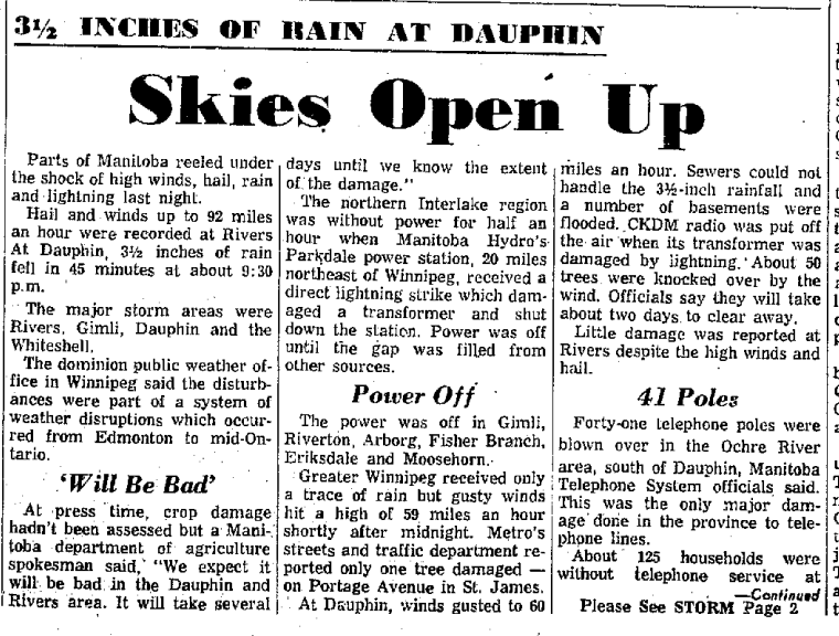
Severe thunderstorms raced through southern Manitoba from Saskatchewan in the evening of July 15, 1964, from the Parklands region of western Manitoba to northern parts of the Red River Valley and the Interlake, and into the Whiteshell.
Hardest hit by the storms was Dauphin where one of the greatest deluges ever recorded in Manitoba occurred. Via the Monthly Record, Dauphin Airport recorded these rainfall rates: 23.6 mm in 5 minutes 40.9 mm in 10 minutes 56.4 mm in 15 minutes 82.6 mm in 30 minutes 86.6 mm in 60 minutes The storm had struck Dauphin about 9:45 pm. As a result of these rainfall rates, basements flooded. The fire department in Dauphin was busy pumping water out of homes. Strong winds up to 80 km/h also brought down power lines and knocked over about 50 trees. 41 power poles were blown over in the Ochre River area, south of Dauphin. Further back in Saskatchewan, Kamsack recorded 63.0 mm of rain which caused the Kamsack Creek to spill its banks, washing away outhouses, sheds and some roads. The storms produced even stronger winds in other parts of southern Manitoba. Rivers Airport recorded a remarkable gust of 146 km/h along with hail. The storm hit there about 8:15 pm and lasted some 15 minutes. Trees were broken, plywood thrown from a construction site and a television antennae was blown down by the winds. Gardens were beaten down by the hail. Portage Southport gusted to 80 km/h and Winnipeg Airport to 97 km/h. Some trees were damaged. Power outages occurred, particularly north of Winnipeg in the Interlake. Gimli, Riverton, Arborg, Fisher Branch, Eriskdale and Moosehorn all faced power outages. |

|
Very little rain fell in Winnipeg however. The heaviest rains with the storms were north of the city. Hail was reported at Gimli. Around 25 mm of rain fell in Neepawa, Ste Rose and Roblin. The rain was badly needed due to a dry summer and in a way actually outweighed the impacts of wind and hail.
Newspaper sources: Winnipeg Tribune July 16 (page 17). Winnipeg Free Press July 16 (page 1). Brandon Sun July 16 (page 1 - as shown above).
Newspaper sources: Winnipeg Tribune July 16 (page 17). Winnipeg Free Press July 16 (page 1). Brandon Sun July 16 (page 1 - as shown above).
|
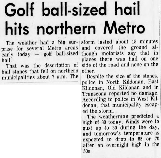
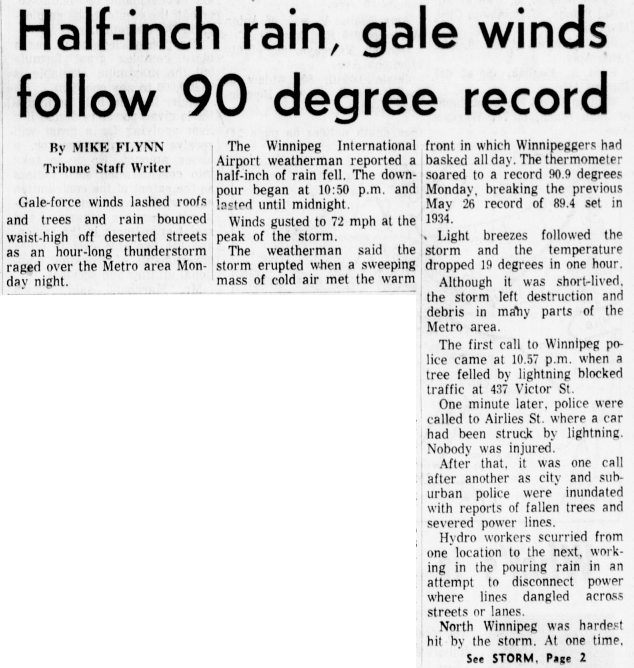
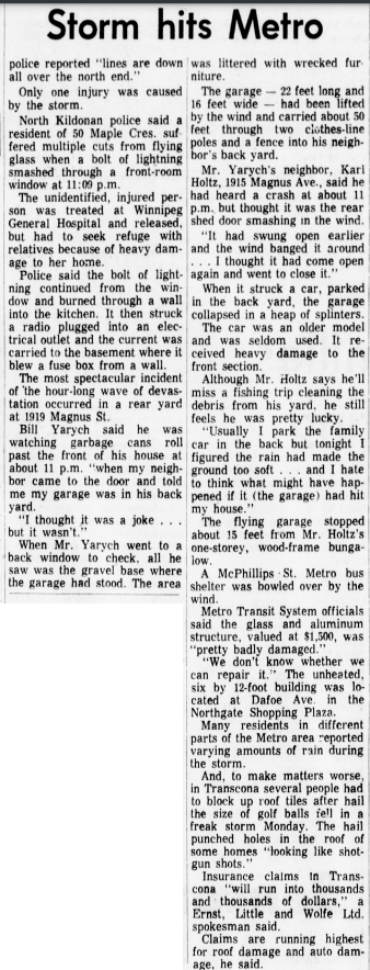
Two severe thunderstorms struck the Winnipeg area on May 26, 1969, the first around 7am and the second in the late evening.
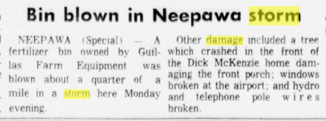
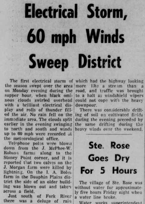
The storm around 7am dropped golf ball-sized hail in northern parts of the Winnipeg area. The storm lasted about 15 minutes, and the hail covered the ground in some parts. North Kildonan, East Kildonan, Old Kildonan and Transcona were hit. In Transcona, the hail reportedly punched holes in some roofs and damaged vehicles. Blossoming fruit trees and garden plants were damaged. Trees reportedly bent over during the storm. The storm was part of a series of thunderstorms and showers which formed along a warm front draped across southern Manitoba during the overnight and early morning. The Grosse Isle area northwest of Winnipeg also reported hail larger than 2.5 cm in diameter around 6am. As the warm front advanced northward, temperatures rose over 30°C in the afternoon. Winnipeg reached 32.8°C, a record high for the date. Humidex values were in the mid thirties. Brandon reached 34.4°C and Morden 35.0°C. Another outbreak of severe thunderstorms struck late in the evening with a cold front. A possible bow echo thunderstorm complex moved through the Winnipeg area between 11 pm and 2 am, producing wind gusts up to 106 km/h at the Airport. The downpour began at 10:50 pm at the Airport. The northern parts of the city were hardest hit again. Trees were knocked down, windows smashed in and power cut off for up to 2 hours in parts of the city. The storm also dropped more hail. Windows at a Safeway store were knocked out with glass strewn over a one-block area. A roof was blown off a new house. A tree felled by lightning blocked traffic at 437 Victor St. The garage of one resident had been lifted by the wind and carried into a neighbours yard. The only injury reported during the storm was from a smashed window after a lightning strike in North Kildonan. The evening storms had originated in western Manitoba. Neepawa experienced wind damage as well earlier in the evening, with hydro and telephones wires down, trees knocked down and windows broken at the Airport. Dauphin was struck by the storms around supper time with gusts up to 97 km/h at the Airport. Very little rain fell in the city itself, but a deluge of rain was reported just south of Fork River to the north of Dauphin. The wind knocked down telephone poles. Two calves were struck by lightning. Significant drifting soil occurred as well with the winds. The highest rainfall amounts via the ECCC Archives for the day: Winnipeg Kildonan Park 37.1 mm Selkirk 22.9 mm Grosse Isle 18.8 mm Steinbach 18.8 mm Winnipeg St Boniface 17.3 mm Stonewall 17.0 mm Winnipeg Airport 12.2 mm |

|
Newspaper sources: Winnipeg Free Press May 26 (page 1 and 5), May 27 (page 1). Winnipeg Tribune May 26 (page 1 - see image on the right), May 27 (page 1 - see image on the right, and page 2). Brandon Sun May 28 (page 9). Dauphin Herald May 28 (page 2). Stonewall Argus and Teulon Times May 28 (page 4).
|
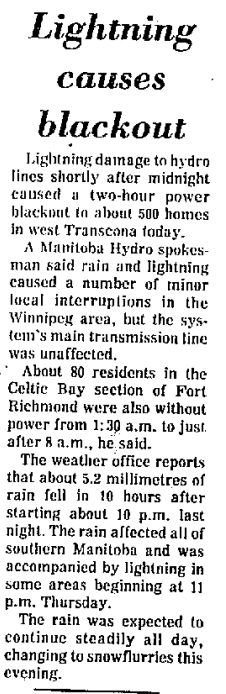
Thunderstorms struck the Winnipeg area just after midnight on March 31, 1978. Lightning from the storm caused a two-hour power outage in west Transcona to about 500 homes. Manitoba Hydro said rain and lightning caused numerous minor power interruptions in the Winnipeg area, such as in Fort Richmond. 5 to 10 mm of rain fell with the system. Locally up to 27 mm fell in St Boniface.
Portage la Prairie reported thunderstorms for 3 hours, from 11pm March 30 to 1 am March 31. 12 mm of rain fell at Southport. Newspaper sources: Winnipeg Free Press Mar 31 (page 5 - seen on the right). |
|
|
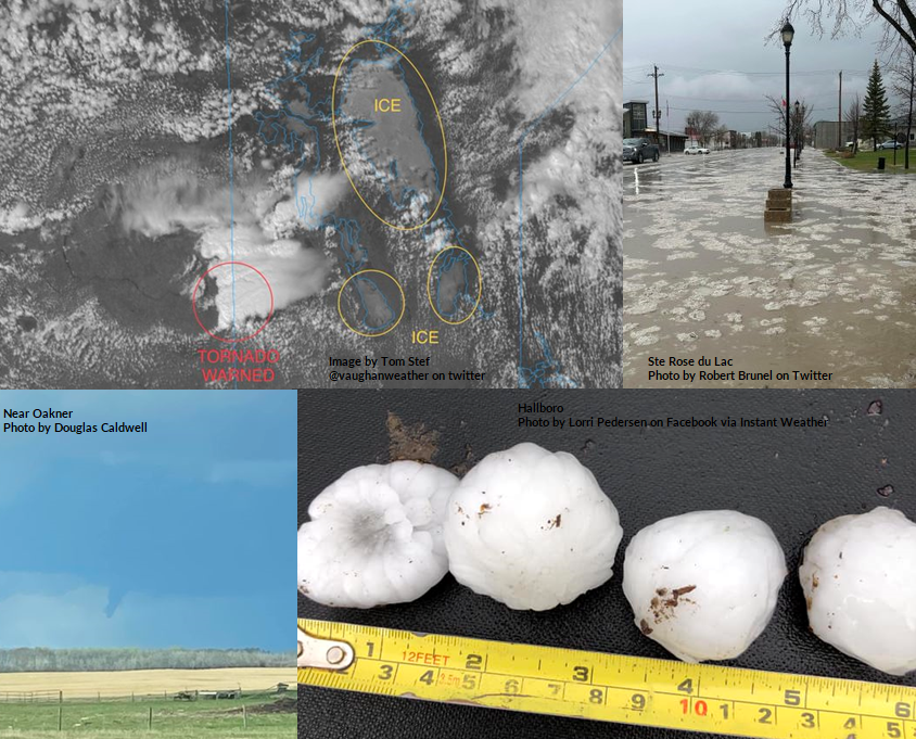
An upper level wave moving through southern Manitoba kicked off the season's first severe thunderstorm outbreak. Instability and wind shear worked perfectly together to form well-organised thunderstorms with large hail, gusty winds and torrential downpours. Although it isn't unheard of to see severe weather that early in the season, it was a little unusual to see as much hail as was witnessed. Pretty much every single thunderstorm that developed produced hail, and often times as large as quarters and loonies. A few isolated stronger storms dropped hail as large as ping pong balls or even golf balls. Winnipeg was hit by at least two severe thunderstorms with hail up to loonie sized. The first storm moved along Portage Avenue from Headingley to downtown. The second hailstorm moved through the southern portion of the city. There was some minor damage to plants and vehicles, and apparently two dealerships in the St James area did have some damage.
One storm even exhibited supercellular characteristics in southwestern Manitoba. Tornado warnings were issued. A funnel cloud was observed near Hamiota, with no evidence of a touchdown. Check out this Word document with a summary of photos from social media and some news stories. It includes links to the photos on the right. |
|
The storms dropped highly variable amounts of rain, ranging from 1 to 45 mm. Ste Rose du Lac suffered significant street flooding from the heavy downpours. In Winnipeg, amounts ranged from a few mm to over 20 mm. Localized wind gusts over 80 km/h were observed, particularly in the Interlake and southeastern Manitoba. The maximum gust recorded was 87 km/h in Petersfield. Click the following links for a summary of observations from the Manitoba Agriculture network: Southwest MB, Southeast MB. Also, here are rainfall amounts from Cocorahs.
A weak trough or cold front moving through southern Manitoba sparked off several severe thunderstorms in the afternoon and evening of August 24, 2023. It had been a warm and humid afternoon with highs in the high twenties along with dewpoints around 20C. In the morning, it was actually quite cloudy with fog patches after some light rain the day before. Skies cleared out in the afternoon. Severe thunderstorms initially developed around the Riding and Turtle Mountains and pushed into the Interlake. By around supper, storms developed in the Red River Valley.
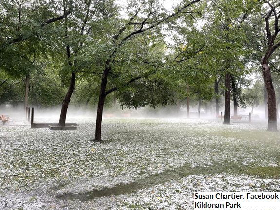
The severe thunderstorms were significant hail and wind makers. One severe storm formed just northwest of Winnipeg Airport and moved through the northern and northeastern portions of the city, through Amber Trails, Garden City, the Kildonans, Transcona and Dugald. It was one of the worst storms to strike the city in years, dropping immense amounts of large hail ranging from nickel to golf ball sized. Damaging winds and torrential downpours accompanied the hail, causing widespread and significant damage and near-zero visibility during the storm. A wind gust of 133 km/h was recorded at the Dugald station owned by Manitoba Agriculture. Trees were uprooted and large branches were knocked down, causing damage to vehicles and buildings. Windows in buildings and cars were smashed and holes in siding and gazebos resulted. Gardens were flattened and fences knocked down. Some street signs were even snapped and a semi truck knocked over by the wind. There was so much hail that it had remained on the ground for at least 3 hours after the storm. Patchy hail fog was also witnessed. It was reported that about 10,000 people lost power during the storms, and a few thousand still were without power the following morning.
Some videos of the hailstorm in Winnipeg are as follows:
https://twitter.com/chriscrond/status/1694859146972340600
https://twitter.com/allenadelacruz/status/1694877283721597043
https://twitter.com/Rexdale_Realist/status/1694860425324531734
https://twitter.com/JeremyDBradley/status/1694862799623569752
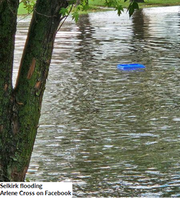
The storms also dropped golf-ball sized hail in Alonsa. Additional storms pushed through the Interlake and eastern Manitoba through the overnight hours, dropping more large hail in spots. Wind gusts of 89 km/h in Oak Point and 88 km/h in Inwood were also recorded. Rainfall amounts were generally not very impressive. The Winnipeg storm dropped between 15 and 25 mm, enough to cause some localized street flooding. Some fields were under water as well. Unofficial rainfall amounts of 100 mm were recorded in the Selkirk area, where there was significant street flooding reported. A private Weather Underground station in Tyndall recorded about 46 mm.
The severe thunderstorms were significant hail and wind makers. One severe storm formed just northwest of Winnipeg Airport and moved through the northern and northeastern portions of the city, through Amber Trails, Garden City, the Kildonans, Transcona and Dugald. It was one of the worst storms to strike the city in years, dropping immense amounts of large hail ranging from nickel to golf ball sized. Damaging winds and torrential downpours accompanied the hail, causing widespread and significant damage and near-zero visibility during the storm. A wind gust of 133 km/h was recorded at the Dugald station owned by Manitoba Agriculture. Trees were uprooted and large branches were knocked down, causing damage to vehicles and buildings. Windows in buildings and cars were smashed and holes in siding and gazebos resulted. Gardens were flattened and fences knocked down. Some street signs were even snapped and a semi truck knocked over by the wind. There was so much hail that it had remained on the ground for at least 3 hours after the storm. Patchy hail fog was also witnessed. It was reported that about 10,000 people lost power during the storms, and a few thousand still were without power the following morning.
Some videos of the hailstorm in Winnipeg are as follows:
https://twitter.com/chriscrond/status/1694859146972340600
https://twitter.com/allenadelacruz/status/1694877283721597043
https://twitter.com/Rexdale_Realist/status/1694860425324531734
https://twitter.com/JeremyDBradley/status/1694862799623569752
The storms also dropped golf-ball sized hail in Alonsa. Additional storms pushed through the Interlake and eastern Manitoba through the overnight hours, dropping more large hail in spots. Wind gusts of 89 km/h in Oak Point and 88 km/h in Inwood were also recorded. Rainfall amounts were generally not very impressive. The Winnipeg storm dropped between 15 and 25 mm, enough to cause some localized street flooding. Some fields were under water as well. Unofficial rainfall amounts of 100 mm were recorded in the Selkirk area, where there was significant street flooding reported. A private Weather Underground station in Tyndall recorded about 46 mm.

|

|

|
|

