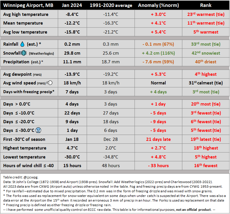
1 - Stats and Rankings
Precipitation - The Forks used as replacement on the 5th, 6th, 10th, 11th, 15th, 16th and 18th, to help account for undercatch of snowfall at the Airport. There was also a serious error with precipitation on the 15th when the Airport recorded an erroneous 3 mm of precipitation in an hour - The Forks used as replacement.
2 - Records
Jan 24 - High minimum dewpoint -4.0°C. Old record -7.0°C in 2017.
Jan 25 - High minimum dewpoint -4.0°C. Old record -6.1°C in 1973.
Jan 25 - High minimum temperature -3.7°C. Old record -4.4°C in 1958.
Jan 28 - High minimum dewpoint -8.1°C. Old record -9.7°C in 2017.
Jan 29 - High dewpoint 0.6°C. Old record -0.1°C in 1992 and 2016.
Jan 29 - High minimum dewpoint -6.4°C. Old record -8.0°C in 1992.
Jan 30 - High dewpoint 1.1°C. Old record -0.3°C in 1993.
Jan 30 - High minimum dewpoint -0.8°C. Old record -7.8°C in 1992.
Jan 30 - High minimum temperature -0.6°C. Old record -6.4°C in 1993.
Jan 31 - High dewpoint 1.2°C. Old record 1.1°C in 2009.
Jan 31 - High minimum dewpoint -4.2°C. Old record -6.7°C in 1993.
Jan 31 - High minimum temperature -4.1°C. Old record -5.2°C in 2020.
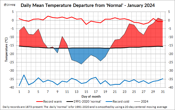
3 - Daily Temperature Departures Graph
4 - Fewest Days Below -20°C up to this Point in the Winter
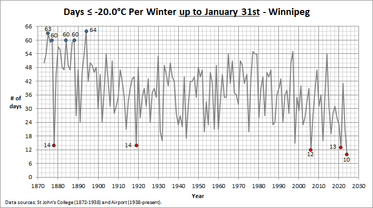
What is also unusual is that Winnipeg had fewer days below -20°C so far this winter than most other cities in the Prairies. Usually, the inverse is true. Edmonton, Regina and Saskatoon all recorded 11 days below -20°C so far. Winnipeg The Forks had only 9 days.
5 - Other Info
A month of extremes across the Prairies... A very warm January in Manitoba thanks to El Nino. The warmest weather occurred in the last few days of the month:
Jan 30 - Stubborn southerly wind kept Winnipeg at 1-3°C, while just to the west it was 6-9°C in a downslope southwesterly flow, including around Portage, Carman and Morden. This warmth reached as close to Winnipeg as Elm Creek. Just east of Riding Mountain, McCreary reached 14.2°C in a gusty WNW wind, just shy of the provincial January record of 14.5°C on January 7, 2003 which occurred at the same station. However, Ethelbert Mb Ag station reached 15.1°C and Garland Mb Fire station 15.6°C, which would be new provincial records for January.
Alberta and Saskatchewan were remarkably mild. Saskatchewan broke its monthly record with a high of 21.1°C at Maple Creek, beating the old record of 19°C. The national January record is 22.2°C in Niagara Falls in 1950. Regina reached double digits for only the second time on record in January. Some backyard stations reached up to 12°C. Edmonton reached 12.4°C, its 3rd warmest January day on record. Snow melted quite rapidly, with fields in the city becoming mostly bare.
In North Dakota, it reached up to 16°C in southwestern portions of the state.
Jan 31 - Another day of extreme warmth. The Forks reached 7.8°C, while some backyard private stations reached almost 9°C. The Airport failed to exceed its record high with a high of only 4.7°C. This might have been at least partially a result of light NW wind off of Lake Manitoba, which is frozen. Temperatures of 6 to 8°C were recorded all around the city, including in the Interlake, east and south of the city. Winnipeg Airport and Elie were a localized cold spot in the Red River Valley. The warmest temperatures were again along the escarpment, from the east side of the Duck Mountains southward to the US border. The hot spot was McCreary at 12.1°C. Morden reached 11.3°C, its 3rd warmest January day on record since 1905.
There was only one cold snap during the month, occurring in the middle of the month. The cold was centered to the west in Alberta and Saskatchewan where lows below -40°C occurred for several days in a row. It was one of the worst cold snaps in the region in decades. Edmonton Airport dipped to -46.6°C, and dipped below -40°C five days in a row. Maple Creek SK reached -42.6°C. This, combined with a high of 21.1°C on the 30th, gave a remarkable temperature amplitude of 63.7°C for the month at the location. Even Calgary Airport dipped to -36.8°C. Most of the lowest values in Alberta were around -48°C. Keg River in northern Alberta dipped to -51.5°C on the 14th, the coldest in Alberta since at least 2004. The station hit 14.4°C later in the month, resulting in a temperature amplitude of 65.9°C for the month, one of the highest ever recorded in Canada. An emergency alert was issued in Alberta to cut down on electricity usage as the province almost ran out of electricity storage capacity during the cold snap. Electricity from Manitoba, Montana and British Columbia were imported to avoid rolling blackouts.
 RSS Feed
