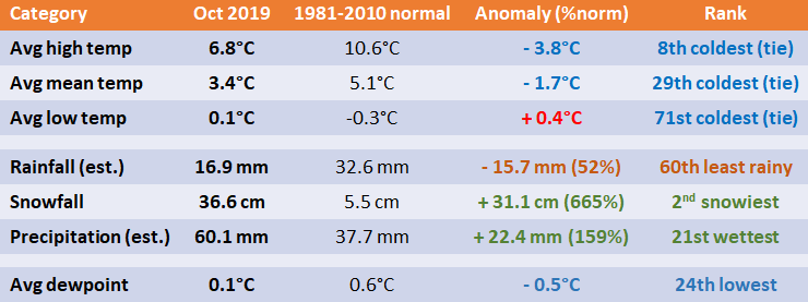
1 - Stats and Rankings
**Note that precipitation is a blend between The Forks and The Airport (XWG) due to undercatching by the Airport gauge during snow events. The Forks precipitation amount is used as replacement during snow days as a result (for water-equivalent).
2 - Records
Oct 10 - High snowfall 21.0 cm. Old record 10.9 cm in 1883. Also 2nd snowiest October day and earliest 20+cm daily snowfall on record since 1872.
Oct 11 - High snowfall 13.0 cm. Old record 3.0 cm in 2006.
Oct 11 - High snow depth 20 cm. Old record 5 cm in 1985. Also highest snow depth in October since 1955 (old record 18 cm on October 31, 1971).
Oct 10-11 - Largest October snowstorm on record since 1872 with 34.0 cm. Previous largest 2-day total 27.9 cm Oct 30-31, 1971. Also the earliest snowstorm to dump 20+cm (old record 20.3 cm in a one-day storm on Oct 16, 1878). Also earliest snowstorm to dump 30+ cm (old record 35.8 cm on Nov 7-8, 1986).
Oct 12 - High snow depth 30 cm. Old record 2 cm in 2006. Also highest snow depth in October since 1955 (old record set the day before)
Oct 13 - High snow depth 18 cm. Old record trace in 1959 and 1985.
Oct 14 - High snow depth 10 cm. Old record 3 cm in 1959.
Oct 15 - High snow depth 4 cm. Old record trace in 1959 and 2018.
Oct 16 - High snow depth 2 cm. First time recorded snow on ground at 12 UTC on this date since 1955.
Oct 17 - Tied high snow depth trace. Tied with 1984, 1992, 1993 and 2002.
3 - An October for the Record Books
The Oct 10-11 Colorado Low Snowstorm:
- Generally, 40 to 70 cm of snow fell between Brandon and Winnipeg, with the highest amounts from Carberry to Portage southward to the US border. This made it one of the worst snowstorms to ever hit southern Manitoba. The area of heaviest snow also stretched as far south as Bismarck and Jamestown in North Dakota. Brandon received 35.2 cm in total, 20.6 cm of which fell on October 11 alone, the 5th highest daily snowfall in October since 1885.
- The mixed precipitation zone flirted Winnipeg most of the event with mostly rain southeast of the city and snow to the west. 30-50 mm of rain fell through southeastern Manitoba. In Winnipeg, the snow mixed with ice pellets for several hours in the morning of October 11. Thundersnow and thunder-ice pellets also occurred east and southeast of the city, including in Steinbach.
- Virtually all main highways were closed during the storm, including highways 1, 2, 3, 10 and 14 (among others). I-29 and I-94 were also closed in North Dakota. Highways in Manitoba did not reopen until late in the day on October 12 or early in the morning on October 13.
- A major hydro disaster with a record number of power outages across southern Manitoba. In total, around 150,000 homes and businesses lost power. The storm is estimated to cost Manitoba Hydro more than 110 million dollars. Thousands of hydro poles, and even some hydro towers, knocked over or snapped. The hydro damages were mostly due to a combination of three factors: (1) the extreme wetness/heaviness of the snow, which stuck to everything; (2) the strong wind gusts between 80 and 100 km/h; (3) the foliage still being present on the trees. At one point, the entire city of Portage was without power and residents were asked to not flush their toilets since lift stations were down. One woman was taken to hospital outside Morden due to carbon monoxide poisoning from a propane heater. Power outages continued in the following weeks after the storm due to the number of poles needing to be replaced and due to weakened poles causing new outages. Some 5,000 residents, mostly from First Nations, were also evacuated until power could be restored.
- An unprecedented disaster to trees in Winnipeg (dubbed ''tree apocalypse''). Tens of thousands of trees were uprooted, knocked over and shredded by the heavy wet snowfall and strong winds. Fallen trees partially or entirely blocked roadways and sidewalks, making travel difficult. One person was injured by a falling tree. The danger of falling trees prompted the city to close city parks until the clean up could be completed. City parks did not fully reopen until November 19. The full clean up could take a year and the city's tree canopy may take ten years to recover.
- States of Emergency were issued by the City of Winnipeg and the Province of Manitoba to facilitate clean up efforts. Crews from Toronto, Saskatoon, Regina and Calgary arrived to Winnipeg to help clean up trees. Crews from Minnesota, Ontario and Saskatchewan were sent in to help Manitoba Hydro replace broken power poles and towers.
- The Winnipeg Floodway was opened on October 9, the first time in the fall on record since 1968. This was a consequence of the storm which was preceded by the rainiest September on record. Soils were already saturated and water levels high prior to the October storm. After the storm, the Red River crest on October 24 in Winnipeg was the highest ever recorded in the fall and reached within half a foot of the crest during the 2019 spring flood. Previously, the latest date the floodway was open was on August 4, 2002. It did not close until November 8. High water advisories were issued for many rivers, including the Red, the Assiniboine and the Souris. The incredibly wet fall also put a damper on harvest operations and the potato harvest suffered for the second year in a row.
- Exceptionally high river levels continued through November.
- As a result of the storm, a long-standing city tradition was cancelled this year. Instead of using a donated tree from a resident, it used an artificial Christmas Tree for City Hall. The tree will be used for a few years. Crews were too busy cleaning up to cut down a tree for City Hall.
Other interesting tidbits:
- This was the second consecutive October to be in the top 30 coldest. Such a streak has not occurred in almost 90 years, since the early 1930s.
- Monthly maximum of 19.1°C was the 24th lowest in October since 1872 and the lowest since 2009 (16.6°C).
- A remarkably small difference between nights and days in October. Nights were slightly warmer than normal but days were significantly colder than normal. The difference between the average high and average low was only 6.7°C, the second smallest in October since 1872 (a small difference between highs and lows is almost exclusively a phenomenon of cold Octobers). Only 10 days dropped below freezing, tied 23rd least since 1872 and the least since 2005. This is an interesting statistic given it was a top 30 coldest October. The warmer nights were aided by cloud cover.
- Interestingly, Montreal had its rainiest/wettest October on record (and by a long shot!).
- To cap off an already bizarre month, a likely landspout occurred near Swan River on October 19,
 RSS Feed
