1 - Stats and Rankings
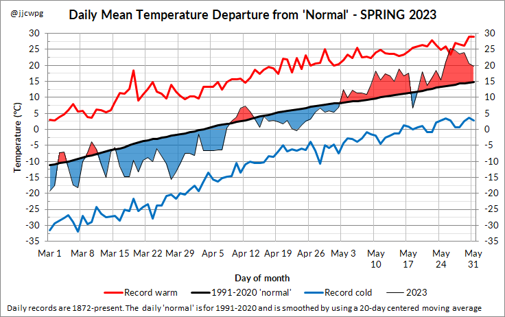
2 - Daily Temperature Departures Graph
|
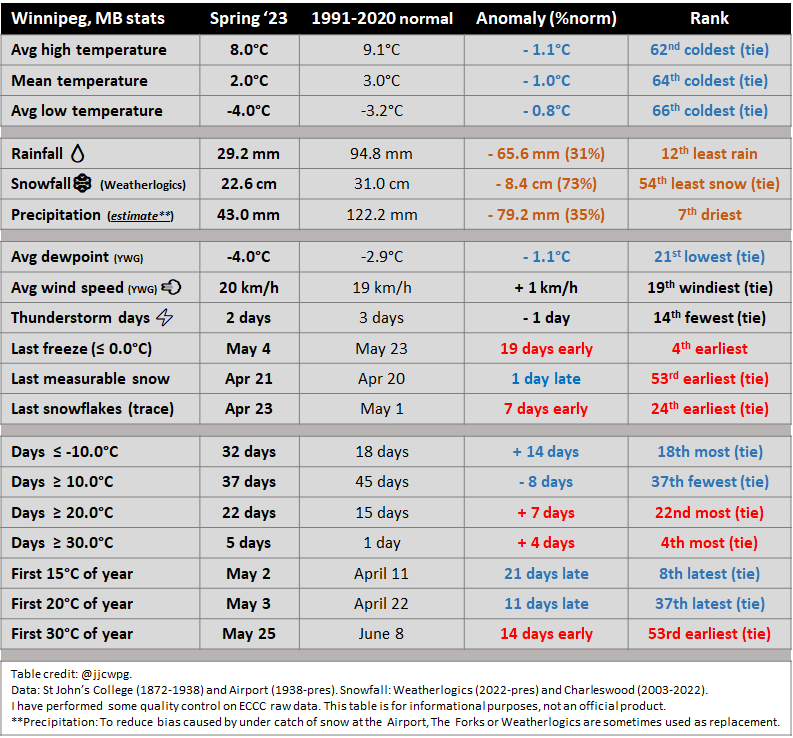
1 - Stats and Rankings 2 - Daily Temperature Departures Graph 1 - Stats and Rankings 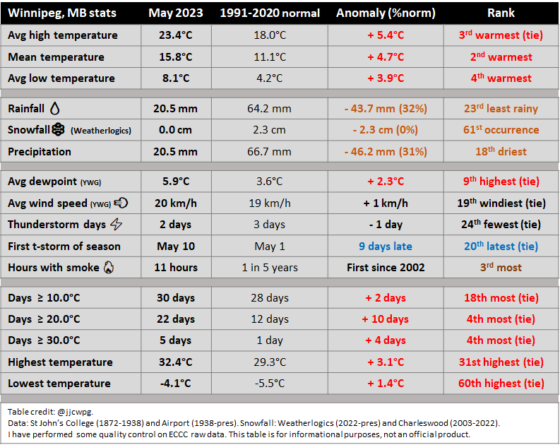 2 - Records May 26 - High minimum 18.4°C. Old record 17.8°C in 1977. 3 - Daily Temperature Departures Graph 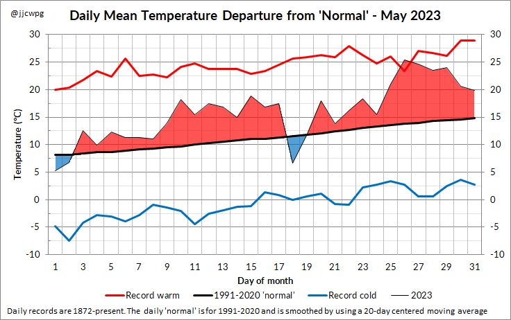 4 - Events May 10 - Severe thunderstorm outbreak across southern Manitoba drops lots of hail, including several large hail reports. Winnipeg received two severe thunderstorms, both producing nickel to loonie sized hail. Click here for a full summary. Smoke - Due to numerous fires in Alberta, northern Saskatchewan and northern BC, there was much more smoke than usual this May. The vast majority of the smoke remained above the surface, which gave cloudier skies and could not be smelled at the surface. I counted at least 8 days with smoke aloft in Winnipeg (possibly a few more - I wasn't watching extremely closely every single day). It occurred mostly in the period of the 14th to 23rd. In the ECCC Archives, we had the first mentions of smoke in the hourly observations in May since 2002. There were also 6 days with smoke causing a reduction in visibility at Winnipeg Airport. Rapid green-up - Due to a very cold April followed by a very warm May, the spring green-up was remarkably fast. May started with little to no green grass or budding trees, but then the trees were mostly fully leaved by the May Long Weekend. Thunderstorms - Note that other parts of the city, particularly in the south, had up to 4 thunderstorm days this May: May 10, 27, 29 and 30. Beausejour received one of the heaviest downpours of the month in Manitoba. On May 30, the town received 43.8 mm of rain in 1 hour (mb ag station) along with a wind gust of 82 km/h. Streets flooded in the town. 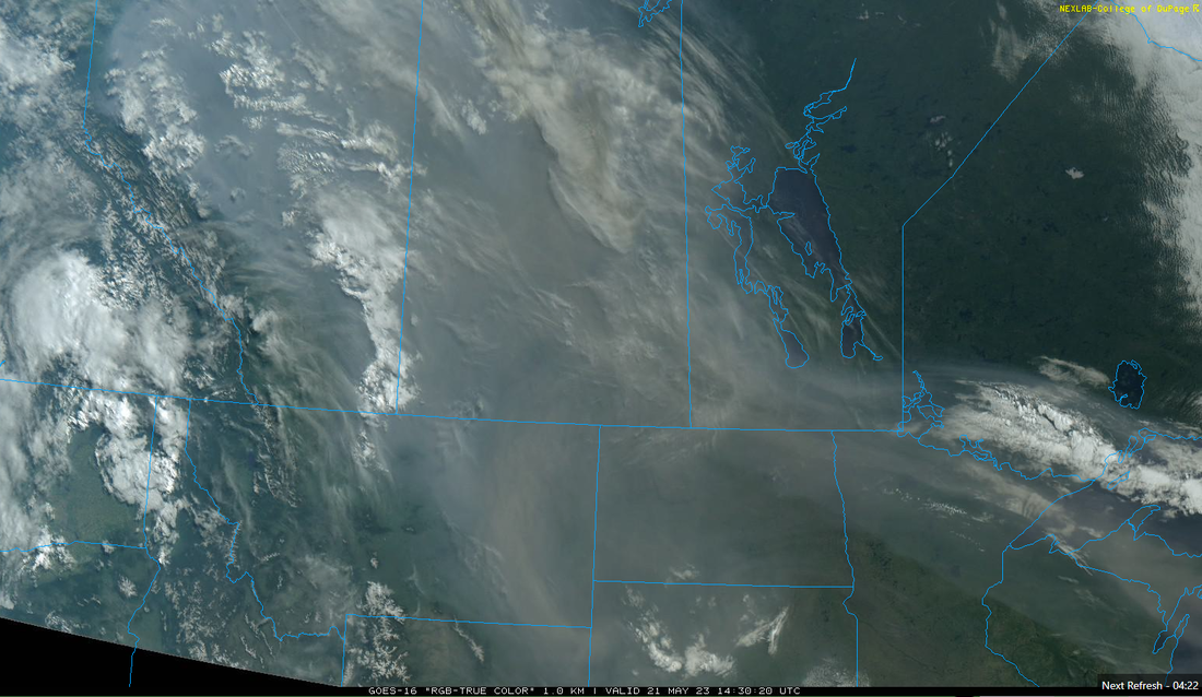 May 21 visible satellite imagery showing widespread smoke from Alberta to the Great Lakes 5 - Driest January to May Period on Record Since 1872 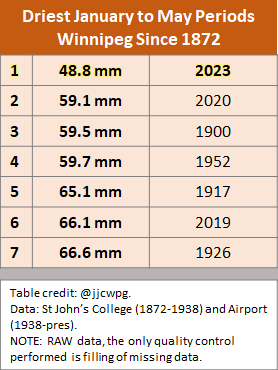 Winnipeg Airport had its driest January to May on record since records began in Winnipeg in 1872. Note that the table above does not account for any snowfall undercatch. My quality-controlled amount is 54.5 mm, which would still be the driest on record. The quality control performed is replacing some undercaught snow-water equivalent amounts from March and April with The Forks or Weatherlogics, which are less prone to undercatch. Last year, we had the 2nd wettest, so it is quite a drastic flip from last year. The impacts of the dryness are less obvious probably due to a late spring which delayed snow melt, leftover moisture from last year, and higher water levels due to record snowfall amounts in North Dakota over the winter. However, some burn bans were issued in some rural municipalities in late May due to the developing dryness.
Note that other parts of the city received more precip, particularly due to more rain in May. Between 60 and 70 mm fell in some other areas. |
Archives
May 2024
|
 RSS Feed
