1 - Stats and Rankings
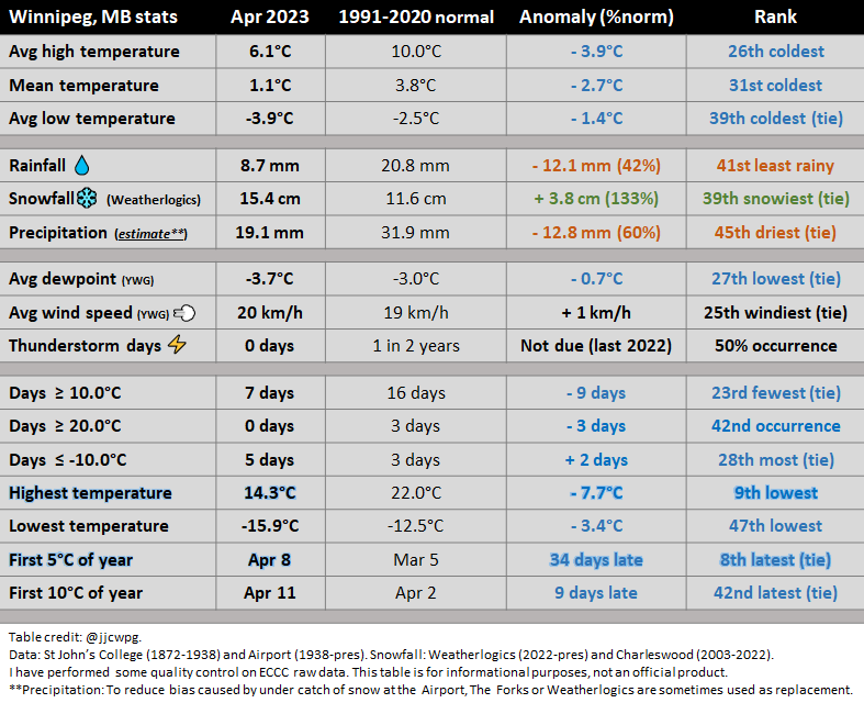
Precipitation: The Forks used Apr 4 and 5 due to under catch of snow at the Airport. Weatherlogics used Apr 20 and 21 because it was more representative of the western half of the city (The Forks / eastern half of city had heavier snow early the 20th - but then also under caught on the 21st). Original precip amount at the Airport 15.5 mm - bias corrections changed it to 19.1 mm.
2 - Records
No records.
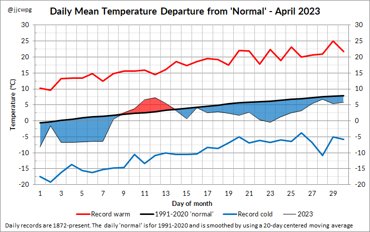
3 - Daily temperature Departures Graph
4 - Events
After a very cold March and start to April, some backyard skating rinks were still usable in the first few days of April. The lateness of spring was largely attributable to deep extensive snow cover in North Dakota and southern Manitoba. North Dakota in particular had a very snowy winter, with snow not melting away until mid or late April in some parts. Fargo had the 6th longest period with snow depth above 2 cm on record. The snow cover had the effect of creating a localized ''pothole of cold'' across North Dakota and southern Manitoba in the first half of April.
The extensive snow cover significantly cooled temperatures from what they could have been during a warm spell around April 11th. The air moving overhead was actually unusually warm for that early in the season, but the snow kept temperatures many degrees colder. This was evidenced on the 11th when western North Dakota, which was snow-free, reached 30°C. Meanwhile, eastern North Dakota struggled to reach above 7°C. Thanks to forests absorbing sunshine, the Whiteshell east of Winnipeg did manage to reach 20°C on the 11th.
First measurable rain event on April 13 and 14th. 10 to 20 mm fell across southeastern Manitoba. Winnipeg only received a couple mm. 5 to 10 mm fell on the 26th with a clipper system.
Two Colorado Lows brought significant snowfall to southern Manitoba:
- April 4-5 Colorado Low
- 15 to 30 cm of snow across southeastern Manitoba. Winnipeg received 10 to 15 cm.
- April 19-21 Colorado Low
- Snowfall amounts were largely driven by terrain effects. 15 to 30 cm along the escarpment, particularly around Morden, Pilot Mound and Crystal City. Only a few cm in the RRV. Winnipeg had barely a couple cm. Believed that easterly winds resulted in much evaporation of precipitation and melting on contact of snow due to warmer temperatures. Southeastern Saskatchewan was hardest hit with blizzard conditions and 30 to 60 cm of snow, particularly around Weyburn. In southwestern Manitoba, wet snow and a period of freezing drizzle caused numerous power outages due to ice accretion on power lines.
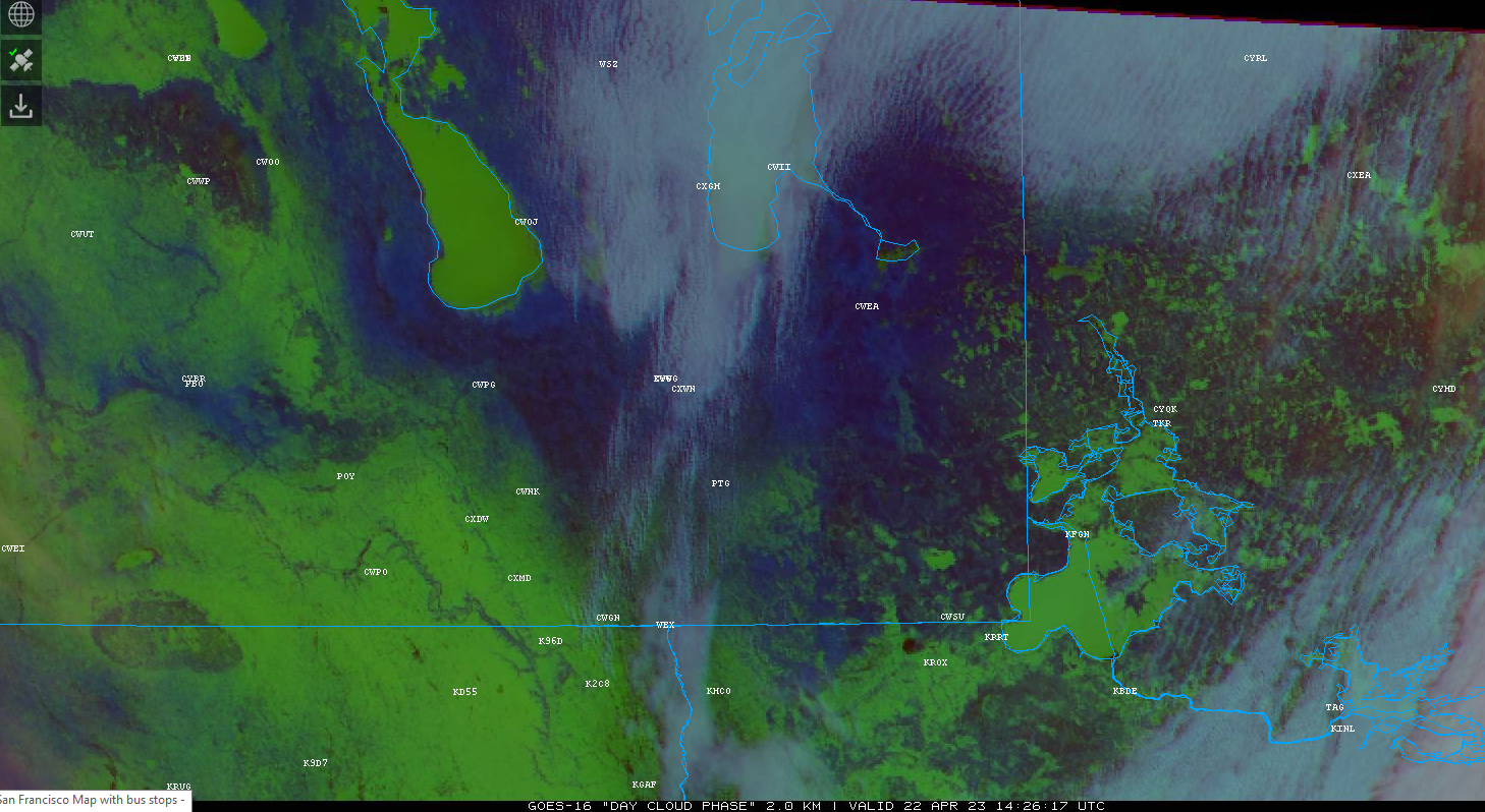
Apr 22 morning satellite image showing extent of snow cover (in green) after snowstorm. Notice high amounts west of escarpment, with a snow shadow in the Red River and Assiniboine River Valleys
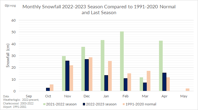
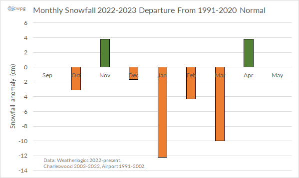
5 - Monthly snowfall for the 2022-2023 season
 RSS Feed
