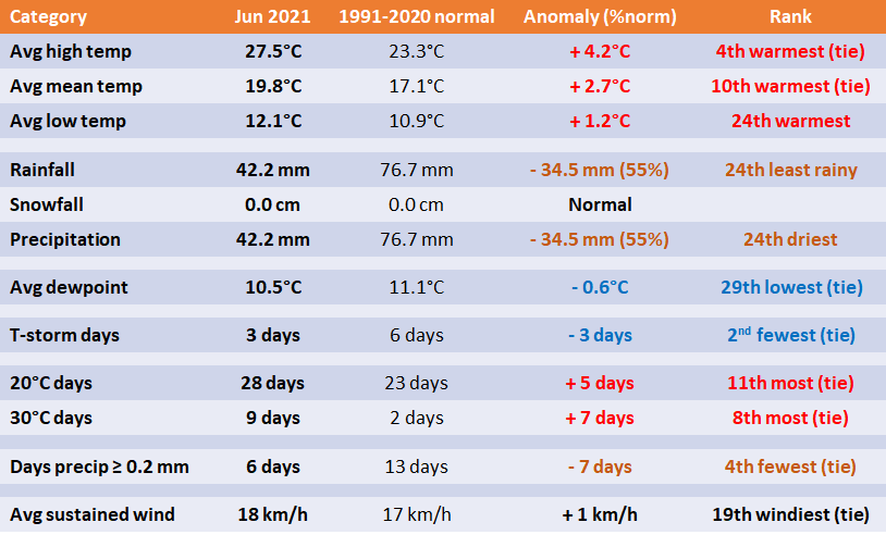
1 - Stats and Rankings
2 - Records
- June 4 - High temperature 36.5°C. Old record 35.6°C in 1988.
- June 5 - High dewpoint 18.7°C. Old record 18.3°C in 2006.
- June 9 - High dewpoint 20.8°C. Old record 20.0°C in 1976.
- June 10 - High minimum dewpoint 14.6°C. Old record 13.9°C in 1956.
- June 21 - Low maximum dewpoint 5.1°C. Old record 7.2°C in 1958.
- June 21 - Low wind chill -2.0. Never had wind chill below zero since 1953.
3 - Miscellaneous
- Driest second half of June (Jun 15-30) on record since 1872 with 0.1 mm (''trace''). Old record 0.5 mm in 1874 and 1912. Note the south side of the city had a shower than brought around 1 mm of rain early June 30.
- Tied 3rd warmest first half of June.
- 9th driest first half of the year (Jan to Jun) since 1873 with 140.2 mm of precipitation. This was the 5th consecutive year to have a top 21 driest first half of the year. In 2017, the first half of the year was the 12th driest (147.1 mm), in 2018 the 21st driest (155.4 mm), in 2019 the driest (104.6mm) and in 2020 the 14th driest (150.1 mm).
- June was the 20th consecutive month of below normal precipitation at Winnipeg Airport.
- High of 36.5°C on June 4 was the 4th earliest date to get this hot (May 21 and 22, 1980, and May 30, 1934). This heat wave is summarized in a blog post.
- Warmest June since 1995.
- Historic ''Heat Dome'' heat wave in western Canada (BC, AB, SK and later MB) late June brought the hottest temperatures ever experienced in Canada. The all-time Canadian high of 45.0°C in Saskatchewan in 1937 was broken numerous times and at numerous locations in BC for 4 consecutive days. Lytton recorded the highest temperature of 49.6°C. Immediately afterward, the town of Lytton was 90% burned down due to a wildfire. Residents had only minutes to evacuate the town.
More to come....
 RSS Feed
